IMAGES TAKEN NEAR TO
Greenwood Crescent, SHEFFIELD, S9 4HE
Introduction
This page details the photographs taken nearby to Greenwood Crescent, S9 4HE by members of the Geograph project.
The Geograph project started in 2005 with the aim of publishing, organising and preserving representative images for every square kilometre of Great Britain, Ireland and the Isle of Man.

There are currently over 7.5m images from over14,400 individuals and you can help contribute to the project by visiting https://www.geograph.org.uk
Image Map
Images are licensed for reuse under creativecommons.org/licenses/by-sa/2.0
Notes
- Clicking on the map will re-center to the selected point.
- The higher the marker number, the further away the image location is from the centre of the postcode.
Image Listing (21 Images Found)
Images are licensed for reuse under creativecommons.org/licenses/by-sa/2.0
Image
Details
Distance

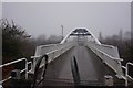
3
Sheffield Parkway crossed by a footbridge
Image: © Colin Pyle
Taken: 13 Dec 2014
0.06 miles
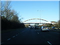
4
Footbridge at the end of Beaumont Road
Footpath and cycle-way over the Parkway at the end of Beaumont Road.
Image: © Martin Speck
Taken: 13 Mar 2009
0.07 miles
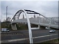
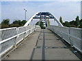
5
Footbridge over the A57 Sheffield Parkway
The footbridge was constructed in 2003 to connect the Manor Park housing estate with the Acres Hill industrial estate
Image: © Graham Hogg
Taken: 6 Apr 2012
0.08 miles
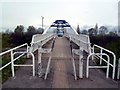
8
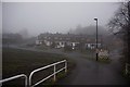
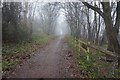
Trans Pennine Trail towards Beaumont Road North
Image: © Ian S
Taken: 18 Dec 2019
0.12 miles
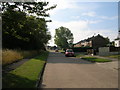
10
Corker Bottom Lane towards Manor Lane, Sheffield
Image: © Ian S
Taken: 18 Dec 2019
0.15 miles