IMAGES TAKEN NEAR TO
Goore Drive, SHEFFIELD, S9 4GF
Introduction
This page details the photographs taken nearby to Goore Drive, S9 4GF by members of the Geograph project.
The Geograph project started in 2005 with the aim of publishing, organising and preserving representative images for every square kilometre of Great Britain, Ireland and the Isle of Man.

There are currently over 7.5m images from over14,400 individuals and you can help contribute to the project by visiting https://www.geograph.org.uk
Image Map
Images are licensed for reuse under creativecommons.org/licenses/by-sa/2.0
Notes
- Clicking on the map will re-center to the selected point.
- The higher the marker number, the further away the image location is from the centre of the postcode.
Image Listing (9 Images Found)
Images are licensed for reuse under creativecommons.org/licenses/by-sa/2.0
Image
Details
Distance
4

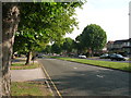
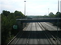
Trans Pennine Trail towards Manor Park, Sheffield
Image: © Ian S
Taken: 18 Dec 2019
0.18 miles
5
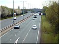
A57 Sheffield Parkway
Looking south east from the footbridge between Manor Park housing estate and Acres Hill industrial estate
Image: © Graham Hogg
Taken: 6 Apr 2012
0.21 miles
7
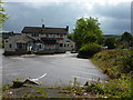
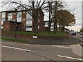
The 3 feathers, a closed pub
At Bowden Wood, off the A6102.
Image: © Peter Barr
Taken: 19 Jul 2011
0.23 miles
8
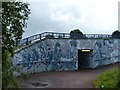
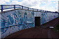
Excellent art-work
Graffiti isn't all a load of daubed rubbish, as this example on an underpass at Manor shows.
Image: © Peter Barr
Taken: 19 Jul 2011
0.24 miles