IMAGES TAKEN NEAR TO
Bowden Wood Crescent, SHEFFIELD, S9 4EA
Introduction
This page details the photographs taken nearby to Bowden Wood Crescent, S9 4EA by members of the Geograph project.
The Geograph project started in 2005 with the aim of publishing, organising and preserving representative images for every square kilometre of Great Britain, Ireland and the Isle of Man.

There are currently over 7.5m images from over14,400 individuals and you can help contribute to the project by visiting https://www.geograph.org.uk
Image Map (Loading...)


Getting Data...Please wait
Leaflet Map data © OpenStreetMap
Images are licensed for reuse under creativecommons.org/licenses/by-sa/2.0
Notes
- Clicking on the map will re-center to the selected point.
- The higher the marker number, the further away the image location is from the centre of the postcode.
Image Listing (7 Images Found)
Images are licensed for reuse under creativecommons.org/licenses/by-sa/2.0
Image
Details
Distance
1
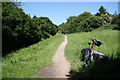
Trans-Pennine Trail
TPT / Route 67 near Bowden Housetads Wood at Darnall
Image: © Richard Croft
Taken: 17 Jun 2010
0.12 miles
2
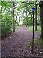
Bowden Housteads Wood
The Trans Pennine Trail in Bowden Housteads Wood.
Image: © Martin Speck
Taken: 18 Jul 2010
0.15 miles
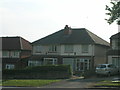
5
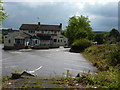
The 3 feathers, a closed pub
At Bowden Wood, off the A6102.
Image: © Peter Barr
Taken: 19 Jul 2011
0.18 miles
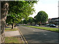
6
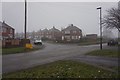
Handsworth Crescent off Handsworth Avenue, Sheffield
Image: © Ian S
Taken: 18 Dec 2019
0.19 miles
7
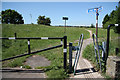
Squeeze stile
Squeeze stile at the end of Handsworth Avenue on the Trans-Pennine Trail / NCN route 67 .... more anti-motorbike measures
Image: © Richard Croft
Taken: 17 Jun 2010
0.21 miles