IMAGES TAKEN NEAR TO
Titterton Close, SHEFFIELD, S9 3TQ
Introduction
This page details the photographs taken nearby to Titterton Close, S9 3TQ by members of the Geograph project.
The Geograph project started in 2005 with the aim of publishing, organising and preserving representative images for every square kilometre of Great Britain, Ireland and the Isle of Man.

There are currently over 7.5m images from over14,400 individuals and you can help contribute to the project by visiting https://www.geograph.org.uk
Image Map (Loading...)


Getting Data...Please wait
Leaflet Map data © OpenStreetMap
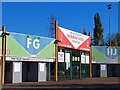
Images are licensed for reuse under creativecommons.org/licenses/by-sa/2.0
Notes
- Clicking on the map will re-center to the selected point.
- The higher the marker number, the further away the image location is from the centre of the postcode.
Image Listing (86 Images Found)
Images are licensed for reuse under creativecommons.org/licenses/by-sa/2.0
Image
Details
Distance

2

Don Valley Stadium
The entrance to the Don Valley Stadium from Worksop Road (A57).
Named after the nearby River Don, this sports complex opened in 1990 for the 1991 World Student Games which were held in Sheffield and has since become a profitable centre for athletics in the area. It is a home for football (Rotherham United FC), Rugby League (Sheffield Eagles RLFC) and Athletics (City of Sheffield Athletic Club). It is the second largest athletics stadium in the UK. More information at http://en.wikipedia.org/wiki/Don_Valley_Stadium (Wikipedia)
Image: © David Dixon
Taken: 5 Apr 2012
0.05 miles
3
The Worksop Road entrance to Don Valley Stadium
Image: © Neil Theasby
Taken: 25 Oct 2010
0.05 miles
4
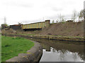
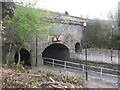
Attercliffe Station remains
The first Attercliffe Station was opened in August 1871, closed on 31 December 1900 and replaced by a new structure which opened the following day. This new station eventually was closed on 26 September 1927. Very little remains of the structure apart from the retaining wall by the side of the canal near to the Worksop Road aqueduct.
Image: © Martin Speck
Taken: 1 Apr 2009
0.06 miles
5
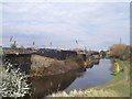
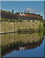
Railway bridge over Worksop Road
The bridge shown in the centre of the photo carries the single track Don Valley freight line, but at one time this was the busy Great Central line.
Beyond that, another bridge carries the present Supertram lines - the electrification masts can just be seen.
In the foreground the canal narrows at the start of the Worksop Road Aqueduct Image - listed grade 2 (List Entry Number 1270905).
Image: © Stephen Craven
Taken: 3 Apr 2012
0.07 miles
7
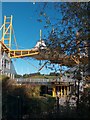
Worksop Road Aqueduct, Sheffield
The Worksop Road Aqueduct was constructed in 1819 to carry the Sheffield and Tinsley Canal over Worksop Road/Darnall Road. The bridge has a 4.0 m height limit which gives a feel for the height of the aqueduct. This photo was taken during a Geograph pre-conference walk (Sheffield 2012).
Image: © Dave Pickersgill
Taken: 3 Apr 2012
0.08 miles
8
Robo was 'ere
At a wide basin halfway along The Sheffield and Tinsley Canal
Image: © Neil Theasby
Taken: 30 Sep 2019
0.08 miles
9
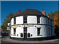
"The Cocked Hat" near Don Valley Stadium
Image: © Neil Theasby
Taken: 25 Oct 2010
0.08 miles
10
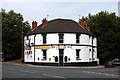
The Cocked Hat, Attercliffe, Sheffield
Traditional pub serving real ale adjacent to the Don Valley Stadium.
Image: © Graham Hogg
Taken: 6 Sep 2010
0.09 miles