IMAGES TAKEN NEAR TO
Broad Oaks, SHEFFIELD, S9 3HJ
Introduction
This page details the photographs taken nearby to Broad Oaks, S9 3HJ by members of the Geograph project.
The Geograph project started in 2005 with the aim of publishing, organising and preserving representative images for every square kilometre of Great Britain, Ireland and the Isle of Man.

There are currently over 7.5m images from over14,400 individuals and you can help contribute to the project by visiting https://www.geograph.org.uk
Image Map (Loading...)


Getting Data...Please wait
Leaflet Map data © OpenStreetMap
Images are licensed for reuse under creativecommons.org/licenses/by-sa/2.0
Notes
- Clicking on the map will re-center to the selected point.
- The higher the marker number, the further away the image location is from the centre of the postcode.
Image Listing (28 Images Found)
Images are licensed for reuse under creativecommons.org/licenses/by-sa/2.0
Image
Details
Distance
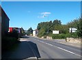
1
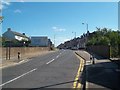
Approaching Darnall along Staniforth Road
The B6200 road passing an entrance sign into the Darnall area of Sheffield.
Image: © Jonathan Clitheroe
Taken: 5 Sep 2012
0.12 miles
2
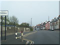
B6200 Staniforth Road at the Darnall boundary
Image: © Colin Pyle
Taken: 7 Apr 2019
0.14 miles
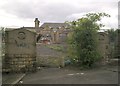
4
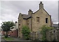
Hammerton Street School
The Girls and Infants entrance, beside the caretakers house.
Ouseburn Road, formerly Hammerton Street.
Image: © Andrew H
Taken: 28 Jul 2010
0.15 miles
5
Council Depot Entrance on Staniforth Road
Works entrance situated on the B6200 road in the Attercliffe area of Sheffield.
Image: © Jonathan Clitheroe
Taken: 5 Sep 2012
0.15 miles
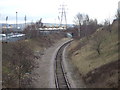
6
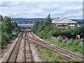
Woodburn Junction
Woodburn Junction on the old Great Central Railway as seen from a footbridge. This was once a busy junction with coal trains coming out of the South Yorkshire Coalfields from the marshalling yard at Wath, in the direction straight ahead. The line off to the right lead to the marshalling yard at Tinsley. An unusual feature of the 1 to 50000 Ordnance Survey map is the incorrect positioning of the footbridge relative to the track junction. As can be seen from the picture, the junction is to the West of the footbridge, not the other way round. The 1 to 25000 Explorer map is more accurate though.
Image: © Martin Speck
Taken: 13 Jul 2008
0.17 miles
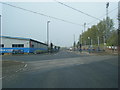
8
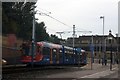
Sheffield Supertram at the Woodbourn Road stop
Image: © Graham Hogg
Taken: 6 Sep 2010
0.17 miles
9
Hammerton Street School
The school viewed from the Girls and Infants entrance on Ouseburn Road (formerly Hammerton Street).
Image: © Andrew H
Taken: 28 Jul 2010
0.18 miles