IMAGES TAKEN NEAR TO
Staniforth Road, SHEFFIELD, S9 3HF
Introduction
This page details the photographs taken nearby to Staniforth Road, S9 3HF by members of the Geograph project.
The Geograph project started in 2005 with the aim of publishing, organising and preserving representative images for every square kilometre of Great Britain, Ireland and the Isle of Man.

There are currently over 7.5m images from over14,400 individuals and you can help contribute to the project by visiting https://www.geograph.org.uk
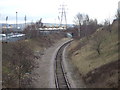
Image Map (Loading...)


Getting Data...Please wait
Leaflet Map data © OpenStreetMap
Images are licensed for reuse under creativecommons.org/licenses/by-sa/2.0
Notes
- Clicking on the map will re-center to the selected point.
- The higher the marker number, the further away the image location is from the centre of the postcode.
Image Listing (50 Images Found)
Images are licensed for reuse under creativecommons.org/licenses/by-sa/2.0
Image
Details
Distance
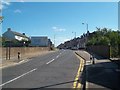
2
Council Depot Entrance on Staniforth Road
Works entrance situated on the B6200 road in the Attercliffe area of Sheffield.
Image: © Jonathan Clitheroe
Taken: 5 Sep 2012
0.06 miles
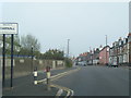
3
Approaching Darnall along Staniforth Road
The B6200 road passing an entrance sign into the Darnall area of Sheffield.
Image: © Jonathan Clitheroe
Taken: 5 Sep 2012
0.07 miles
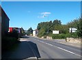
4
B6200 Staniforth Road at the Darnall boundary
Image: © Colin Pyle
Taken: 7 Apr 2019
0.10 miles
5
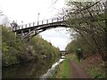
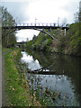
Supertram Footbridge 7B, Sheffield and Tinsley Canal
The footbridge that passes over the canal, joining Roundel Street to the Attercliffe Supertram stop. Taken during the Geograph Conference 2012 first guided walk.
Image: © David P Howard
Taken: 3 Apr 2012
0.14 miles
6
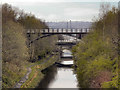
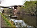
Bridges Over The Sheffield and Tinsley Canal
Looking along the Sheffield and Tinsley Canal, towards Sheffield, from Shirland Lane at Attercliffe.
Image: © David Dixon
Taken: 5 Apr 2012
0.14 miles
7
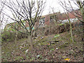
Derelict buildings above the canal
Derelict brick buildings of Roundel Street, on the edge of the canal cutting. This view gives some idea of the depth of the cutting and also of the geology that the navvies had to contend with (exposed at the top of the slope are coal measures strata of mudstone and sandstone). The photographer location can be identified with the "group of Geographers" in David Howard's photo Image
Image: © Stephen Craven
Taken: 3 Apr 2012
0.14 miles
8
Supertram footbridge
Bridge #7B on the Sheffield & Tinsley Canal provides pedestrian access to the Attercliffe tram stop
Image: © Graham Hogg
Taken: 16 Nov 2020
0.14 miles
9
Bridges over Sheffield & Tinsley Canal
In the foreground is a bridge for the Sheffield Supertram, in the background the B6200.
Image: © Paul Gillett
Taken: 3 Apr 2012
0.14 miles
10
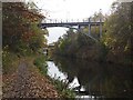
Pedestrian Bridge
This bridge takes pedestrians across the Sheffield and Tinsley Canal near Attercliffe.
Image: © Anne Burgess
Taken: 3 Apr 2012
0.15 miles