IMAGES TAKEN NEAR TO
Locke Drive, SHEFFIELD, S9 3DH
Introduction
This page details the photographs taken nearby to Locke Drive, S9 3DH by members of the Geograph project.
The Geograph project started in 2005 with the aim of publishing, organising and preserving representative images for every square kilometre of Great Britain, Ireland and the Isle of Man.

There are currently over 7.5m images from over14,400 individuals and you can help contribute to the project by visiting https://www.geograph.org.uk
Image Map (Loading...)


Getting Data...Please wait
Leaflet Map data © OpenStreetMap
Images are licensed for reuse under creativecommons.org/licenses/by-sa/2.0
Notes
- Clicking on the map will re-center to the selected point.
- The higher the marker number, the further away the image location is from the centre of the postcode.
Image Listing (15 Images Found)
Images are licensed for reuse under creativecommons.org/licenses/by-sa/2.0
Image
Details
Distance
1
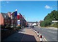
Staniforth Road in Darnall
New residential properties situated alongside the B6200 road which cuts across the north east corner of this grid square.
Image: © Jonathan Clitheroe
Taken: 5 Sep 2012
0.08 miles
3
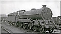
EX-Great Central Class B7 4-6-0 at Darnall Locomotive Depot
A forlorn survivor of the very competent Robinson Class 9Q 4-6-0s, which were worn out struggling over the Woodhead Line in World War Two. No. 1386, still in very dirty LNER livery in 1949, was former LNER No. 5034, built as recently as 8/22 and was about to be withdrawn in 6/49. (See also Image]).
Image: © Ben Brooksbank
Taken: 10 Apr 1949
0.13 miles
4
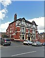
"The Terminus Tavern" public house in Darnall
Image: © Neil Theasby
Taken: 31 Aug 2022
0.13 miles
5
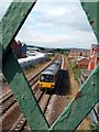
Train approaching Darnall Station
A Sheffield to Lincoln train viewed through a footbridge to the west of the station.
Image: © Graham Hogg
Taken: 3 Sep 2011
0.17 miles
6
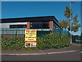
Warehouse To Let - Parkway Rise Industrial Estate
Image: © Neil Theasby
Taken: 25 Oct 2010
0.18 miles
7
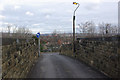
Kettlebridge Road, Attercliffe
At this point Kettlebridge Road crosses the Sheffield - Worksop railway by means of this very narrow bridge, presenting a considerable hazard to traffic.
Image: © Stephen McKay
Taken: 25 Feb 2007
0.20 miles
8
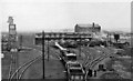
Darnall Locomotive Depot
View eastward of the Depot, in relatively pristine condition just six years after it was opened (on 11/4/43), a 'thoroughly modern' steam depot that was required urgently in World War Two to replace the very antiquated and confined Depot at Neepsend. These were the principal ex-Great Central Depots in Sheffield, providing many of the locomotives handling the passenger and - immense - freight traffic originating in the area and conveyed on the ex-GC main axes, Manchester - Sheffield - Nottingham and the South/Doncaster - Scunthorpe - Grimsby/Lincoln etc. In 1950 in the Eastern Region of BR it was coded 39B (in the Manchester District) and had an allocation of 95, comprising:- 18 4-6-0s, 1 4-4-2, 30 2-8-0s, 21 0-6-0s, 2 4-4-2Ts, 18 0-6-2Ts, 3 0-6-0Ts and 2 0-4-0Ts. The photograph shows a representative selection on a quiet Sunday morning. The Depot did not last long: it was closed to steam on 17/6/63 and totally on 4/10/65.
Image: © Ben Brooksbank
Taken: 10 Apr 1949
0.22 miles
9
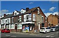
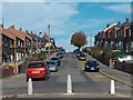
Corner shop in Darnall
At the junction of Staniforth Road and Gainsford Road
Image: © Neil Theasby
Taken: 31 Aug 2022
0.22 miles
10
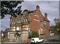
The Ball Inn, Darnall Road, Sheffield
Closed and unlikely to re-open as a pub.
Image: © Andrew H
Taken: Unknown
0.23 miles