IMAGES TAKEN NEAR TO
Ouse Road, SHEFFIELD, S9 3AD
Introduction
This page details the photographs taken nearby to Ouse Road, S9 3AD by members of the Geograph project.
The Geograph project started in 2005 with the aim of publishing, organising and preserving representative images for every square kilometre of Great Britain, Ireland and the Isle of Man.

There are currently over 7.5m images from over14,400 individuals and you can help contribute to the project by visiting https://www.geograph.org.uk
Image Map (Loading...)


Getting Data...Please wait
Leaflet Map data © OpenStreetMap
Images are licensed for reuse under creativecommons.org/licenses/by-sa/2.0
Notes
- Clicking on the map will re-center to the selected point.
- The higher the marker number, the further away the image location is from the centre of the postcode.
Image Listing (14 Images Found)
Images are licensed for reuse under creativecommons.org/licenses/by-sa/2.0
Image
Details
Distance
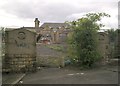
1
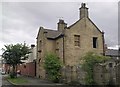
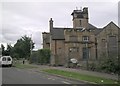
Hammerton Street School
The Girls and Infants entrance, beside the caretakers house.
Ouseburn Road, formerly Hammerton Street.
Image: © Andrew H
Taken: 28 Jul 2010
0.05 miles
3
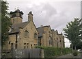
Hammerton Street School
View from Ouseburn Croft
Image: © Andrew H
Taken: 28 Jul 2010
0.06 miles
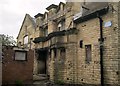
4
Hammerton Street School
The school viewed from the Girls and Infants entrance on Ouseburn Road (formerly Hammerton Street).
Image: © Andrew H
Taken: 28 Jul 2010
0.06 miles
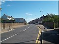
6
B6200 Staniforth Road at the Darnall boundary
Image: © Colin Pyle
Taken: 7 Apr 2019
0.10 miles
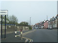
8
Approaching Darnall along Staniforth Road
The B6200 road passing an entrance sign into the Darnall area of Sheffield.
Image: © Jonathan Clitheroe
Taken: 5 Sep 2012
0.12 miles
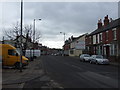
9
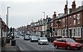
Streets in The North 1
The B6200 Staniforth Road looking west from Shirland Road. This was once the main A57 Liverpool to Lincoln road before the Mosborough Parkway was built in the early 1990s, I think.
Image: © Bobby Clegg
Taken: 23 Jan 2015
0.14 miles
10
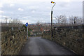
Kettlebridge Road, Attercliffe
At this point Kettlebridge Road crosses the Sheffield - Worksop railway by means of this very narrow bridge, presenting a considerable hazard to traffic.
Image: © Stephen McKay
Taken: 25 Feb 2007
0.15 miles