IMAGES TAKEN NEAR TO
Deadmans Hole Lane, SHEFFIELD, S9 1QQ
Introduction
This page details the photographs taken nearby to Deadmans Hole Lane, S9 1QQ by members of the Geograph project.
The Geograph project started in 2005 with the aim of publishing, organising and preserving representative images for every square kilometre of Great Britain, Ireland and the Isle of Man.

There are currently over 7.5m images from over14,400 individuals and you can help contribute to the project by visiting https://www.geograph.org.uk
Image Map (Loading...)


Getting Data...Please wait
Leaflet Map data © OpenStreetMap
Images are licensed for reuse under creativecommons.org/licenses/by-sa/2.0
Notes
- Clicking on the map will re-center to the selected point.
- The higher the marker number, the further away the image location is from the centre of the postcode.
Image Listing (47 Images Found)
Images are licensed for reuse under creativecommons.org/licenses/by-sa/2.0
Image
Details
Distance
1
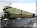
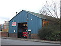
Sterecycle site on Sheffield Road, Tinsley
One of many industrial units placed as close as planning allows to the pavement and to allow ease of access to maintain their plant. I thought Planning Authorities had the power to insist that industrial buildings were bordered with some decorative vegetation such as grass, hedges, shrubs, trees or even, dare I say it flowering plants where they meet public thoroughfares and rights of way. Even now, there are very few business sites in the area that have any 'landscaping' at all.
Image: © Nic Franklin-Woolley
Taken: 21 Feb 2010
0.06 miles
2
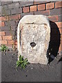
Old milestone
During the summer of 2018 the pavement was relayed and the plate disappeared from the stone. The 'authorities' were questioned and the plate was to be put back. It hasn't happened. But the stone remains by the side of Deadman's Hole Lane.
Image: © Chris Minto
Taken: 31 Oct 2018
0.07 miles
3
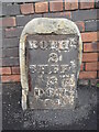
Old milestone
In March 2018 this milestone on the Tinsley to Doncaster tollroad (1764 -1873), now A6178, was the only one of the 5 remaining posts to have retained its plate.
Image: © Chris Minto
Taken: 11 Mar 2018
0.07 miles
4
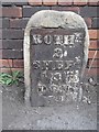
Old Milestone by the A6178, Templeborough, Rotherham
Metal plate attached to stone post by the A6178, in parish of ROTHERHAM (ROTHERHAM District), Templeborough, at junction of Deadmans Hole Lane, West of Magna, in pavement, backing onto brick wall, on North side of road. Erected by the Tinsley & Doncaster turnpike trust in the 18th/19th century.
Inscription reads:-
On back left hand side:
: field / 4 :
On face:
: ROTH.M / 2 / SHEF.D / 4 / DON.R / 14 :
On back right hand side:
: Rother.M / 2 / Doncaster / 1(4)¦ter / 3 :
Milestone Society National ID: YS_DNSF14.
Image: © C Minto
Taken: 1 Jan 1993
0.07 miles
5

The Magna Museum Tinsley Rotherham
The derelict steelworks has been converted into an
interesting museum to steel. wind whistles through
the walkways so coats are advised even in the summer
Image: © Jack Hill
Taken: 10 Oct 2001
0.08 miles
7
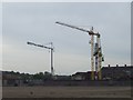
Deadman's Hole
Cranes working at Deadman's Hole. I have read that Deadman's Hole and Deadman's Hole Lane take their names from human remains found in a nearby Roman cemetery.
Image: © Martin Speck
Taken: 25 May 2008
0.10 miles
8
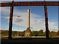
Magna Science Centre, Templeborough
This is a view of a stainless exhaust chimney viewed from inside what looks like a travelling crane gantry.
Image: © Bobby Clegg
Taken: 18 Oct 2008
0.14 miles
9

Tinsley - Halfpenny Footbridge
For an alternative view, please see Image For more information on the bridge, please see http://en.wikipedia.org/wiki/River_Don,_South_Yorkshire#Halfpenny_Bridge
Image: © Dave Bevis
Taken: 10 Mar 2007
0.15 miles
10

Darwins on Sheffield Rd, Templeborough
One of the industrial 'barns' at Tinsley/Templeborough between Sheffield and Rotherham. How about some landscaping as there is precious little greenery in the whole area or are planners happy to leave near-by residents without any green space at all?
Image: © Nic Franklin-Woolley
Taken: 30 Mar 2010
0.15 miles