IMAGES TAKEN NEAR TO
Fife Street, SHEFFIELD, S9 1NR
Introduction
This page details the photographs taken nearby to Fife Street, S9 1NR by members of the Geograph project.
The Geograph project started in 2005 with the aim of publishing, organising and preserving representative images for every square kilometre of Great Britain, Ireland and the Isle of Man.

There are currently over 7.5m images from over14,400 individuals and you can help contribute to the project by visiting https://www.geograph.org.uk
Image Map
Images are licensed for reuse under creativecommons.org/licenses/by-sa/2.0
Notes
- Clicking on the map will re-center to the selected point.
- The higher the marker number, the further away the image location is from the centre of the postcode.
Image Listing (5 Images Found)
Images are licensed for reuse under creativecommons.org/licenses/by-sa/2.0
Image
Details
Distance
2

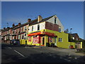
Newman Road Wincobank
In the valley below is Tinsley viaduct and the M1 motorway.
Image: © Steve Fareham
Taken: 28 Aug 2008
0.18 miles
3
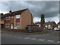
Junction of Maple Croft Crescent and Newman Road, Wincobank
Image: © Neil Theasby
Taken: 30 Aug 2011
0.20 miles
4
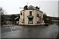
The Wincobank Hotel
A classic triangular corner pub. Now displaying a Thwaites sign, but would have been a Stone's, Ward's or Tetley's pub in the past.
Image: © David Lally
Taken: 2 Jan 2010
0.23 miles
5
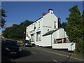
Wincobank Hotel, Wincobank, Sheffield
Junction of Newman Road and Merton Lane.
See http://www.geograph.org.uk/photo/1645462 for an alternative view.
Image: © JThomas
Taken: 27 Sep 2014
0.24 miles