IMAGES TAKEN NEAR TO
Ridge View Close, SHEFFIELD, S9 1EE
Introduction
This page details the photographs taken nearby to Ridge View Close, S9 1EE by members of the Geograph project.
The Geograph project started in 2005 with the aim of publishing, organising and preserving representative images for every square kilometre of Great Britain, Ireland and the Isle of Man.

There are currently over 7.5m images from over14,400 individuals and you can help contribute to the project by visiting https://www.geograph.org.uk
Image Map
Images are licensed for reuse under creativecommons.org/licenses/by-sa/2.0
Notes
- Clicking on the map will re-center to the selected point.
- The higher the marker number, the further away the image location is from the centre of the postcode.
Image Listing (20 Images Found)
Images are licensed for reuse under creativecommons.org/licenses/by-sa/2.0
Image
Details
Distance
1
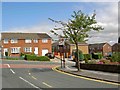
Junction of Jenkin Avenue and Jenkin Road
Wincobank high above the Don Valley near Meadowhall Shopping centre.
Image: © Steve Fareham
Taken: 28 Aug 2008
0.07 miles
2
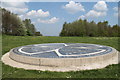
The Star-Crossed Queen
The Star-Crossed Queen is an artwork which commemorates Cartimandua, the ruler of the Brigante tribe at the time when the nearby Wincobank Fort was built.
Image: © Dave Pickersgill
Taken: 7 May 2013
0.14 miles
3
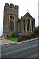
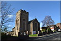
The Parish Church of St Margaret, Brightside
Image: © David Lally
Taken: 18 Nov 2010
0.19 miles
4
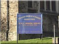
St Margaret's Church Sign, Jenkin Road, Brightside, Sheffield
Image: © Terry Robinson
Taken: 4 Feb 2014
0.19 miles
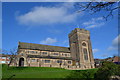
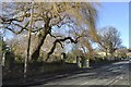
5
St Margaret's Church, Jenkin Road, Brightside, Sheffield
Note the steepness of Jenkin Road … which will form part of Stage 2 of the Tour de France 2014 Route Fortunately at this point the riders will be going downhill! … see …
Image
See also …
Image
Image
Image: © Terry Robinson
Taken: 4 Feb 2014
0.19 miles
6
St Margaret's Church, viewed from Stupton Road, Brightside, Sheffield
Image: © Terry Robinson
Taken: 4 Feb 2014
0.20 miles
7

Newman Road Wincobank
In the valley below is Tinsley viaduct and the M1 motorway.
Image: © Steve Fareham
Taken: 28 Aug 2008
0.21 miles
8
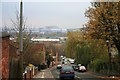
The view down Jenkin Road
Looking over the heavily industrialised Don Valley
Image: © David Lally
Taken: 18 Nov 2010
0.22 miles
10
Brightside Recreation Ground, Jenkin Road, Brightside, Sheffield - 3
Note the steepness of Jenkin Road … which will form part of Stage 2 of the Tour de France 2014 Route Fortunately at this point the riders will be going downhill! … see …
Image
See also …
Image
Image
Image
Image: © Terry Robinson
Taken: 4 Feb 2014
0.22 miles