IMAGES TAKEN NEAR TO
Amos Road, SHEFFIELD, S9 1BX
Introduction
This page details the photographs taken nearby to Amos Road, S9 1BX by members of the Geograph project.
The Geograph project started in 2005 with the aim of publishing, organising and preserving representative images for every square kilometre of Great Britain, Ireland and the Isle of Man.

There are currently over 7.5m images from over14,400 individuals and you can help contribute to the project by visiting https://www.geograph.org.uk
Image Map (Loading...)


Getting Data...Please wait
Leaflet Map data © OpenStreetMap
Images are licensed for reuse under creativecommons.org/licenses/by-sa/2.0
Notes
- Clicking on the map will re-center to the selected point.
- The higher the marker number, the further away the image location is from the centre of the postcode.
Image Listing (91 Images Found)
Images are licensed for reuse under creativecommons.org/licenses/by-sa/2.0
Image
Details
Distance
5
Tour de France 2014 Route - Jenkin Road, Brightside, Sheffield - 3
This is the last bit of the Cote de Jenkin Road … taken from (near enough) the same
spot as picture 2 … but looking the other way. At the bottom of the hill, the riders
will make a sharp right turn onto Meadowhall Road, which leads to Brightside Lane
… and then it's just a few flat miles to the finish at the English Institute for Sport.
UPDATE IN JUNE 2014
The finalised route now confirms that the riders will be ascending Jenkin Road at this point ...
Not descending as originally planned! See picture 2 in this series
For more views and information about this site … see …
Image
Image
For other views of Tour de France 2014 route …see …
Image
Image
Image
Image
Image
Image
… and follow the links from …
Image
Image: © Terry Robinson
Taken: 4 Feb 2014
0.08 miles
7
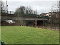
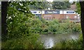
Meadowhall Way Bridge crossing The River Don
Image: © Richard Humphrey
Taken: 31 Mar 2018
0.09 miles
8
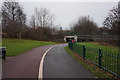
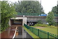
Trans Pennine Trail goes under Meadowhall Way
Image: © Ian S
Taken: 21 Dec 2016
0.10 miles
10
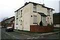
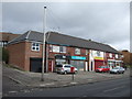
"The Rising Sun" falls
Closed pub on Jenkin Road, Brightside.
Image: © David Lally
Taken: 18 Nov 2010
0.12 miles