IMAGES TAKEN NEAR TO
Holywell Road, SHEFFIELD, S9 1BE
Introduction
This page details the photographs taken nearby to Holywell Road, S9 1BE by members of the Geograph project.
The Geograph project started in 2005 with the aim of publishing, organising and preserving representative images for every square kilometre of Great Britain, Ireland and the Isle of Man.

There are currently over 7.5m images from over14,400 individuals and you can help contribute to the project by visiting https://www.geograph.org.uk
Image Map
Images are licensed for reuse under creativecommons.org/licenses/by-sa/2.0
Notes
- Clicking on the map will re-center to the selected point.
- The higher the marker number, the further away the image location is from the centre of the postcode.
Image Listing (71 Images Found)
Images are licensed for reuse under creativecommons.org/licenses/by-sa/2.0
Image
Details
Distance
1
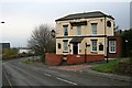
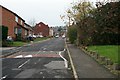
"The Railway", Brightside
Surviving ex-Tetley's pub on the corner of Holywell Road and Dearne Street.
Image: © David Lally
Taken: 18 Nov 2010
0.00 miles
2
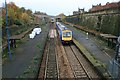
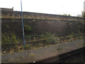
Trains passing through the former Brightside station
For much more information than I could ever provide see Ben Brooksbank's http://www.geograph.org.uk/profile/44502 from 1961 Image
Image: © David Lally
Taken: 18 Nov 2010
0.03 miles
3
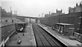
Brightside Station
View NE, towards Rotherham (Masborough), Leeds/York; ex-Midland Sheffield - Leeds/York etc. main line. This is one of the two main lines that run through the Don Valley between Sheffield and Rotherham, passing through a succession of great steelworks and associated industry. Both the ex-Midland (here) and the ex-Great Central lines were immensely busy with freight traffic and heaven to the 'train-watcher' if to no one else. Brightside station was not closed until quite recently (30/1/95) when Meadowhall Interchange and the Sheffield Super-Tram supplanted it.
Image: © Ben Brooksbank
Taken: 23 Apr 1961
0.03 miles
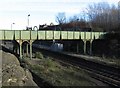
4
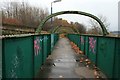
Footbridge over Brightside station
Would have provided access to the Sheffield-bound platform from Holywell Road, before the station closed in 1995.
Image: © David Lally
Taken: 18 Nov 2010
0.03 miles
6
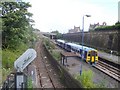
Former Brightside station, Sheffield
The station was open to passengers from 1848 to 1995, by which time it had been replaced by the one serving the new Meadowhall shopping complex half a mile along the line.
Image: © Stephen Craven
Taken: 5 Nov 2016
0.04 miles
7
Brightside Station
The disused station at Brightside which closed on 30 January 1995. Trains now stop at Meadowhall Interchange. See Ben Brooksbank's 1961 photograph of Image
Image: © Martin Speck
Taken: 19 Jul 2009
0.04 miles
8
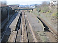
Brightside railway station (site), Sheffield
Opened in 1838 by the Sheffield & Rotherham Railway, this station closed in 1995. View south west towards Attercliffe Road and Sheffield.
Image: © Nigel Thompson
Taken: 27 Mar 2010
0.04 miles
9
Brightside - station footbridge
The station closed in the 1980's, but the platforms and footbridge (carrying a right-of-way) remain. Immediately before closure, there were only 3 or 4 trains a day from Brightside Station. This is a bit of a contrast to the 15-or-so trains an hour that serve the current Meadowhall Station, half a mile to the north-east.
Image: © Dave Bevis
Taken: 22 Nov 2008
0.05 miles
10
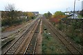
Line toward Sheffield
From the footbridge over the former Brightside Station.
Image: © David Lally
Taken: 18 Nov 2010
0.05 miles