IMAGES TAKEN NEAR TO
Le-Brun Square, WORKSOP, S81 9LS
Introduction
This page details the photographs taken nearby to Le-Brun Square, S81 9LS by members of the Geograph project.
The Geograph project started in 2005 with the aim of publishing, organising and preserving representative images for every square kilometre of Great Britain, Ireland and the Isle of Man.

There are currently over 7.5m images from over14,400 individuals and you can help contribute to the project by visiting https://www.geograph.org.uk
Image Map
Images are licensed for reuse under creativecommons.org/licenses/by-sa/2.0
Notes
- Clicking on the map will re-center to the selected point.
- The higher the marker number, the further away the image location is from the centre of the postcode.
Image Listing (7 Images Found)
Images are licensed for reuse under creativecommons.org/licenses/by-sa/2.0
Image
Details
Distance
2
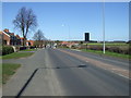
Doncaster Road (A60), Costhorpe
Heading north.
Image: © JThomas
Taken: 16 Mar 2014
0.21 miles
4
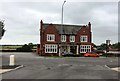
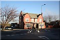
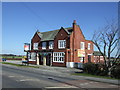
The Riddell Arms in Carlton-in-Lindrick
Pub-restaurant situated on the A60 Road towards the northern end of the village.
Image: © Jonathan Clitheroe
Taken: 2 Aug 2017
0.23 miles
6
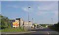
Carlton Industrial Estate
Entrance from Rotherham Baulk.
Image: © Steve Fareham
Taken: 29 May 2008
0.23 miles