IMAGES TAKEN NEAR TO
Glamis Road, WORKSOP, S81 9DR
Introduction
This page details the photographs taken nearby to Glamis Road, S81 9DR by members of the Geograph project.
The Geograph project started in 2005 with the aim of publishing, organising and preserving representative images for every square kilometre of Great Britain, Ireland and the Isle of Man.

There are currently over 7.5m images from over14,400 individuals and you can help contribute to the project by visiting https://www.geograph.org.uk
Image Map
Images are licensed for reuse under creativecommons.org/licenses/by-sa/2.0
Notes
- Clicking on the map will re-center to the selected point.
- The higher the marker number, the further away the image location is from the centre of the postcode.
Image Listing (5 Images Found)
Images are licensed for reuse under creativecommons.org/licenses/by-sa/2.0
Image
Details
Distance
1
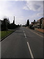
Long Lane
Long Lane in Carlton gets its name, I assume, from the fact it is a lane and long. It is longer than the grid square is wide.
Image: © Michael Patterson
Taken: 22 Mar 2006
0.11 miles
2
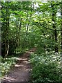
Path in Wallingwells Wood
There are woodland walks available right by the edge of the village of Carlton in Lindrick.
Image: © Andrew Hill
Taken: 4 Sep 2010
0.19 miles
3
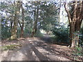
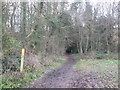
Bridleway in Carlton Wood
Woodland of a veritable age with an abundance of yew trees on show. This woodland path is popular with horse-riders and following heavy rain earlier in the day, parts of this track has been reduced to quagmires. I predictably hit the dirt in one of these areas.
Image: © Jonathan Clitheroe
Taken: 2 May 2016
0.20 miles
5

Field near Carlton in Lindrick
Looking north towards houses in the village from the path near Carlton Hall Farm.
Image: © Andrew Hill
Taken: 4 Sep 2010
0.24 miles