IMAGES TAKEN NEAR TO
Green Farm Court, WORKSOP, S81 9BJ
Introduction
This page details the photographs taken nearby to Green Farm Court, S81 9BJ by members of the Geograph project.
The Geograph project started in 2005 with the aim of publishing, organising and preserving representative images for every square kilometre of Great Britain, Ireland and the Isle of Man.

There are currently over 7.5m images from over14,400 individuals and you can help contribute to the project by visiting https://www.geograph.org.uk
Image Map
Images are licensed for reuse under creativecommons.org/licenses/by-sa/2.0
Notes
- Clicking on the map will re-center to the selected point.
- The higher the marker number, the further away the image location is from the centre of the postcode.
Image Listing (22 Images Found)
Images are licensed for reuse under creativecommons.org/licenses/by-sa/2.0
Image
Details
Distance
1
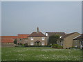
North House Farm
A nat house. The farm buildings are listed. http://www.britishlistedbuildings.co.uk/en-241380-barn-and-attached-range-of-outbuildings-
Image: © Jonathan Thacker
Taken: 21 Apr 2014
0.05 miles
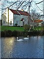
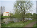
3
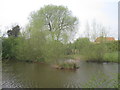
The village pond, North Carlton (2)
Image: © Jonathan Thacker
Taken: 21 Apr 2014
0.06 miles
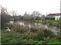
7
Village Pond
The village pond in Carlton has been there since at least the 1700s.
Image: © Michael Patterson
Taken: 22 Mar 2006
0.08 miles
8
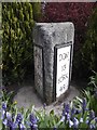
Old Milestone by the A60, Doncaster Road, North Carlton
Metal plate attached to stone post by the A60, in parish of CARLTON IN LINDRICK (BASSETLAW District), North Carlton, Doncaster Road in flower bed, on East side of road, next to Granary Court. Worksop triangle and iron plate, erected by the Balby to Worksop turnpike trust in the 19th century.
Inscription reads:-
: WOR / 4 / LON / 151 : : DON / 13 / YORK / 49 :
Carved benchmark on top.
Milestone Society National ID: NT_WKDN04.
Image: © C Minto
Taken: 1 Jul 1992
0.10 miles
9
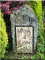
Old Milestone
Old milestone on the A.60 at Carlton In Lindrick, Nottinghamshire. For overall view see http://www.geograph.org.uk/photo/4595228
Image: © Keith Evans
Taken: 20 Jun 2015
0.10 miles