IMAGES TAKEN NEAR TO
Gildingwells Road, WORKSOP, S81 8QE
Introduction
This page details the photographs taken nearby to Gildingwells Road, S81 8QE by members of the Geograph project.
The Geograph project started in 2005 with the aim of publishing, organising and preserving representative images for every square kilometre of Great Britain, Ireland and the Isle of Man.

There are currently over 7.5m images from over14,400 individuals and you can help contribute to the project by visiting https://www.geograph.org.uk
Image Map
Images are licensed for reuse under creativecommons.org/licenses/by-sa/2.0
Notes
- Clicking on the map will re-center to the selected point.
- The higher the marker number, the further away the image location is from the centre of the postcode.
Image Listing (20 Images Found)
Images are licensed for reuse under creativecommons.org/licenses/by-sa/2.0
Image
Details
Distance
1
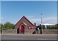
Woodsetts Methodist Church
Building established in 1896
Image: © Neil Theasby
Taken: 1 Aug 2013
0.04 miles
3
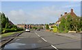
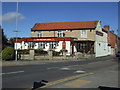
Woodsetts Village Hall
On Gildingwells Road.
Image: © JThomas
Taken: 16 Mar 2014
0.14 miles
4
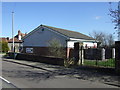
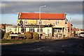
The Butchers Arms, Woodsetts
The pub closed just a few weeks before this photo was taken, apparently the second time the business has failed in recent years.
Image: © Graham Hogg
Taken: 19 Feb 2019
0.16 miles
5

Butchers Arms, Woodsetts
Sadly closed in January 2019 and possibly not to reopen?
Image: © Chris Morgan
Taken: 19 Feb 2019
0.16 miles
6
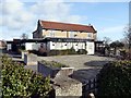
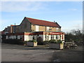
The Butchers Arms
Hostelry in Woodsetts
Image: © Richard Croft
Taken: 10 Dec 2008
0.16 miles
9
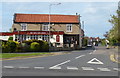
The Butchers Arms in Woodsetts
A public house on the corner of Gildingwells Road and Dinnington Road.
Image: © Mat Fascione
Taken: 22 May 2016
0.17 miles
10
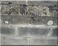
Ordnance Survey Cut Mark
This OS cut mark can be found on the north face of St George's Church. It marks a point 64.185m above mean sea level.
Image: © Adrian Dust
Taken: 23 May 2016
0.19 miles