IMAGES TAKEN NEAR TO
Blyth Road, WORKSOP, S81 8JL
Introduction
This page details the photographs taken nearby to Blyth Road, S81 8JL by members of the Geograph project.
The Geograph project started in 2005 with the aim of publishing, organising and preserving representative images for every square kilometre of Great Britain, Ireland and the Isle of Man.

There are currently over 7.5m images from over14,400 individuals and you can help contribute to the project by visiting https://www.geograph.org.uk
Image Map
Images are licensed for reuse under creativecommons.org/licenses/by-sa/2.0
Notes
- Clicking on the map will re-center to the selected point.
- The higher the marker number, the further away the image location is from the centre of the postcode.
Image Listing (40 Images Found)
Images are licensed for reuse under creativecommons.org/licenses/by-sa/2.0
Image
Details
Distance
1
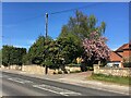
Blyth Road, Oldcotes
A cherry tree is looking its best
Image: © Graham Hogg
Taken: 26 Apr 2021
0.02 miles
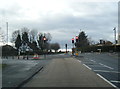
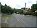
3
Blyth Road, Oldcotes
Originally part of the Barnby Moor to Rotherham turnpike, providing a connection off the Great North Road. Now the A634.
Image: © Alan Murray-Rust
Taken: 20 Jan 2015
0.06 miles
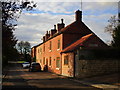
4
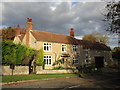
House on Main Street, Oldcotes
Oldcotes is on the edge of the stone belt, though most of the village is now of brick.
Image: © Jonathan Thacker
Taken: 1 Nov 2018
0.07 miles
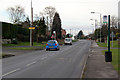
5
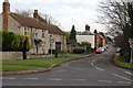
Main Street, Oldcotes
The two main roads through the village don't include the village 'Main Street'.
Image: © Alan Murray-Rust
Taken: 20 Jan 2015
0.08 miles
6
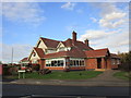
Roadhouse at Oldcotes
Strategically placed at the junction of two main roads.
Image: © Jonathan Thacker
Taken: 1 Nov 2018
0.09 miles
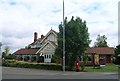
9
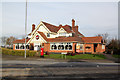
Brewers Fayre at Oldcotes
No evidence on the outside of the pub of its name, the chain name clearly considered to be more important. Maps show that it is the King William IV, and the current website also refers to it as such.
Image: © Alan Murray-Rust
Taken: 20 Jan 2015
0.09 miles