IMAGES TAKEN NEAR TO
Lindrick Dale, WORKSOP, S81 8BB
Introduction
This page details the photographs taken nearby to S81 8BB by members of the Geograph project.
The Geograph project started in 2005 with the aim of publishing, organising and preserving representative images for every square kilometre of Great Britain, Ireland and the Isle of Man.

There are currently over 7.5m images from over14,400 individuals and you can help contribute to the project by visiting https://www.geograph.org.uk
Image Map
Images are licensed for reuse under creativecommons.org/licenses/by-sa/2.0
Notes
- Clicking on the map will re-center to the selected point.
- The higher the marker number, the further away the image location is from the centre of the postcode.
Image Listing (15 Images Found)
Images are licensed for reuse under creativecommons.org/licenses/by-sa/2.0
Image
Details
Distance
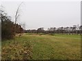
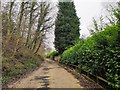
2
Footpath Skirting Lindrick Golf Course
Public footpath which follows the rough at the course's edge before disappearing into the undergrowth. Despite observing the signs (or yellow posts in this instance) and notwithstanding the risk of a stray ball cleaving my skull, i still feel strangely furtive while scampering across golf courses. Probably an irrational fear of being shouted down and pulled up for a dress-code violation or other random infringement.
Image: © Jonathan Clitheroe
Taken: 19 Jul 2016
0.06 miles

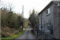
5
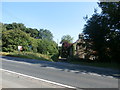
Entrance to Lindrick Dale
View from the A57 road at the head of this magnesian limestone valley. A run of private properties limit any opportunity to explore this dale.
Image: © Jonathan Clitheroe
Taken: 19 Jul 2016
0.16 miles
6
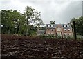
Dale House, Lindrick Dale
Viewed under the high gate of this well-screened property.
Image: © Neil Theasby
Taken: 12 Aug 2014
0.17 miles
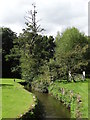
7
Lindrick Dale from the A57
The river Ryton runs down the right hand side of Lindrick Dale.
Image: © Martin Lee
Taken: 22 Jan 2012
0.18 miles
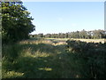
8
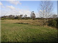
Lindrick Common
Lindrick Common is dominated by Lindrick golf course. The A57 is behind the trees in the distance.
Image: © Michael Patterson
Taken: 26 Feb 2006
0.20 miles

10
Wood Mill Bottoms
Near Lindrick Dale
Image: © Stephen Ostler
Taken: 31 Dec 2019
0.21 miles