IMAGES TAKEN NEAR TO
Gildingwells Road, WORKSOP, S81 8AS
Introduction
This page details the photographs taken nearby to Gildingwells Road, S81 8AS by members of the Geograph project.
The Geograph project started in 2005 with the aim of publishing, organising and preserving representative images for every square kilometre of Great Britain, Ireland and the Isle of Man.

There are currently over 7.5m images from over14,400 individuals and you can help contribute to the project by visiting https://www.geograph.org.uk
Image Map
Images are licensed for reuse under creativecommons.org/licenses/by-sa/2.0
Notes
- Clicking on the map will re-center to the selected point.
- The higher the marker number, the further away the image location is from the centre of the postcode.
Image Listing (5 Images Found)
Images are licensed for reuse under creativecommons.org/licenses/by-sa/2.0
Image
Details
Distance
1

Brands Lane
A track that runs between Dinnibgton and Woodsetts
Image: © Graham Hogg
Taken: 19 Feb 2019
0.17 miles
2
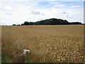
View towards a small area of woodland
Image: © Jonathan Thacker
Taken: 5 Aug 2016
0.18 miles
3
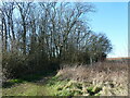
NEW
Bridleway by a small area of woodland near Woodsetts
Image: © Jonathan Thacker
Taken: 18 Mar 2025
0.21 miles
4
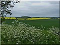
English countryside near Woodsetts
The view north-east from a corner of Dewidales Wood near Woodsetts in South Yorkshire. On the distant horizon, to the right of centre, can be seen the towering headgear of Harworth Colliery in north Nottinghamshire, which has since closed and been demolished.
Image: © Mike Nield
Taken: 5 Jun 2013
0.22 miles
5
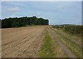
Track across open fields
The track is called Brands Lane on the 1:25,000 map.
Image: © Andrew Hill
Taken: 4 Sep 2010
0.22 miles