IMAGES TAKEN NEAR TO
Carlton Road, WORKSOP, S81 7LQ
Introduction
This page details the photographs taken nearby to Carlton Road, S81 7LQ by members of the Geograph project.
The Geograph project started in 2005 with the aim of publishing, organising and preserving representative images for every square kilometre of Great Britain, Ireland and the Isle of Man.

There are currently over 7.5m images from over14,400 individuals and you can help contribute to the project by visiting https://www.geograph.org.uk
Image Map
Images are licensed for reuse under creativecommons.org/licenses/by-sa/2.0
Notes
- Clicking on the map will re-center to the selected point.
- The higher the marker number, the further away the image location is from the centre of the postcode.
Image Listing (8 Images Found)
Images are licensed for reuse under creativecommons.org/licenses/by-sa/2.0
Image
Details
Distance
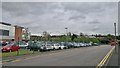
3
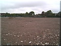
Former site of running track, Valley School
This is very much 'work in progress,' showing the present building site for the new Valley school, where there has been a running track until the beginning of May 2006. In the distance, you can see the council allotments, the main entrance of which are on Gateford Road.
Image: © Tim Hallam
Taken: 13 May 2006
0.11 miles
8
Valley School
A school bus has arrived early for home time
Image: © Chris Morgan
Taken: 18 May 2015
0.24 miles