IMAGES TAKEN NEAR TO
Claylands Close, WORKSOP, S81 7AJ
Introduction
This page details the photographs taken nearby to Claylands Close, S81 7AJ by members of the Geograph project.
The Geograph project started in 2005 with the aim of publishing, organising and preserving representative images for every square kilometre of Great Britain, Ireland and the Isle of Man.

There are currently over 7.5m images from over14,400 individuals and you can help contribute to the project by visiting https://www.geograph.org.uk
Image Map
Images are licensed for reuse under creativecommons.org/licenses/by-sa/2.0
Notes
- Clicking on the map will re-center to the selected point.
- The higher the marker number, the further away the image location is from the centre of the postcode.
Image Listing (17 Images Found)
Images are licensed for reuse under creativecommons.org/licenses/by-sa/2.0
Image
Details
Distance
1
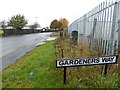
Gardeners Way sign
Does what is says and gives access to allotments.
Image: © Steve Fareham
Taken: 28 Oct 2015
0.05 miles
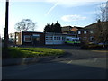
2
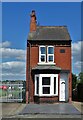
Thin house on Gateford Road
The stone plaque tells us that the house was named "West View" when it was built in 1912.
Image: © Neil Theasby
Taken: 27 May 2022
0.09 miles
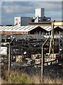
3
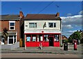
Dukeries Industrial Estate
The grandly named Dukeries Industrial Estate is home to the Oxo cube production factory. During the 1/200 of a second that my camera shutter was open the factory no doubt produced enough Oxo cubes to last a large family a lifetime. Perhaps. STOP PRESS March 2012- I am listening to a programe on Radio 4 recorded at the Oxo factory. They produce 50 cubes per second, or 1 quarter of a cube in the time my shutter was open. So much for my speculation!
Image: © Michael Patterson
Taken: 24 Feb 2006
0.10 miles
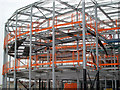

8
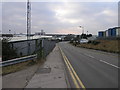
At The Dukeries industrial estate
Looking towards the Oxo factory operated by Premier Foods.
Image: © Neil Theasby
Taken: 9 Feb 2016
0.14 miles
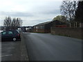
10
Baulk Lane
Motor vehicles and cycles prohibited according to the sign, but this is surely facing the wrong way?.
Image: © Graham Hogg
Taken: 18 May 2015
0.19 miles