IMAGES TAKEN NEAR TO
Blyth, WORKSOP, S81 0TX
Introduction
This page details the photographs taken nearby to S81 0TX by members of the Geograph project.
The Geograph project started in 2005 with the aim of publishing, organising and preserving representative images for every square kilometre of Great Britain, Ireland and the Isle of Man.

There are currently over 7.5m images from over14,400 individuals and you can help contribute to the project by visiting https://www.geograph.org.uk
Image Map
Images are licensed for reuse under creativecommons.org/licenses/by-sa/2.0
Notes
- Clicking on the map will re-center to the selected point.
- The higher the marker number, the further away the image location is from the centre of the postcode.
Image Listing (9 Images Found)
Images are licensed for reuse under creativecommons.org/licenses/by-sa/2.0
Image
Details
Distance
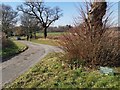
2
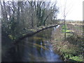
The River Ryton
Looking south near Hodsock.
Image: © JThomas
Taken: 16 Mar 2014
0.08 miles
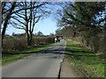
3
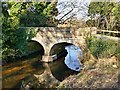
Bridge over the River Ryton
Carrying the access road to Hodsock Priory
Image: © Graham Hogg
Taken: 26 Feb 2019
0.09 miles
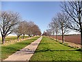
4
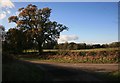
Autumn colours
The road that leads to Hodsock, the low sun highlights the autumn colours.
Image: © roger geach
Taken: 13 Nov 2010
0.10 miles
5
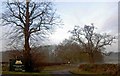
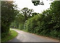
Road to Hodsock Priory
Famous for snowdrops and bluebells
Image: © Chris Morgan
Taken: 26 Feb 2019
0.10 miles
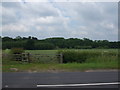
9
No through road to the A1, the start of Plantation Lane
Near Hodsock red bridge.
Image: © Steve Fareham
Taken: 14 May 2008
0.24 miles