IMAGES TAKEN NEAR TO
Cowper Close, WORKSOP, S81 0RQ
Introduction
This page details the photographs taken nearby to Cowper Close, S81 0RQ by members of the Geograph project.
The Geograph project started in 2005 with the aim of publishing, organising and preserving representative images for every square kilometre of Great Britain, Ireland and the Isle of Man.

There are currently over 7.5m images from over14,400 individuals and you can help contribute to the project by visiting https://www.geograph.org.uk
Image Map
Images are licensed for reuse under creativecommons.org/licenses/by-sa/2.0
Notes
- Clicking on the map will re-center to the selected point.
- The higher the marker number, the further away the image location is from the centre of the postcode.
Image Listing (9 Images Found)
Images are licensed for reuse under creativecommons.org/licenses/by-sa/2.0
Image
Details
Distance
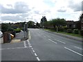
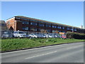
3
Browning Close, Worksop
A residential street near the eastern edge of the town.
Image: © Andrew Hill
Taken: 11 Aug 2010
0.16 miles
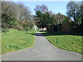
5
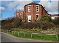
Neglected old wing at Bassetlaw Hospital
Image: © Neil Theasby
Taken: 9 Feb 2016
0.20 miles
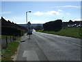
7
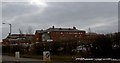
Bassettlaw district hospital, Worksop
Looking from Kilton Hill
Image: © Steve Fareham
Taken: 22 Feb 2010
0.23 miles
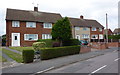
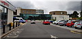
8
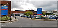
Blyth Road Entrance to Bassetlaw Hospital
This is the main entrance to this busy hospital.
Image: © Paul Collins
Taken: 30 Jul 2018
0.23 miles