IMAGES TAKEN NEAR TO
The Oval, WORKSOP, S81 0AQ
Introduction
This page details the photographs taken nearby to The Oval, S81 0AQ by members of the Geograph project.
The Geograph project started in 2005 with the aim of publishing, organising and preserving representative images for every square kilometre of Great Britain, Ireland and the Isle of Man.

There are currently over 7.5m images from over14,400 individuals and you can help contribute to the project by visiting https://www.geograph.org.uk
Image Map
Images are licensed for reuse under creativecommons.org/licenses/by-sa/2.0
Notes
- Clicking on the map will re-center to the selected point.
- The higher the marker number, the further away the image location is from the centre of the postcode.
Image Listing (21 Images Found)
Images are licensed for reuse under creativecommons.org/licenses/by-sa/2.0
Image
Details
Distance
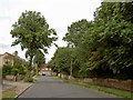
1
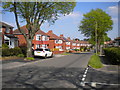
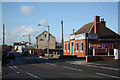
Shepherd's Avenue, Worksop
Seen from the end of Sunfield Avenue.
Image: © Richard Vince
Taken: 5 May 2018
0.16 miles
2
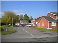
Holmefield Close, Worksop
Off Shepherd's Avenue.
Image: © Richard Vince
Taken: 5 May 2018
0.16 miles
4
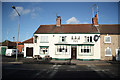
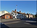
Kilton Inn
Popular hostelry on Kilton Road, Worksop
Image: © Richard Croft
Taken: 27 Oct 2010
0.19 miles
6
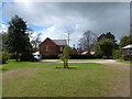
Car park for Mr Straw's House, (National Trust)
Image: © SMJ
Taken: 27 Apr 2013
0.20 miles
8
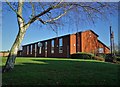
Jesus Christ of Latter Day Saints Church, Worksop
Image: © Neil Theasby
Taken: 10 Jan 2020
0.22 miles
9
Mr Straw's House
A 'time-capsule' National Trust property.
Image: © John H Darch
Taken: 14 Jul 2005
0.22 miles
10
Mr. Straw's House
7 Blyth Grove, Worksop, is a 1920's semi which belonged to William & Walter Shaw. After their parents died in the 1930's it was left untouched, and remains as it was then. It is now in the care of the National Trust & open to the public.
Image: © Lynne Kirton
Taken: 4 Oct 2003
0.22 miles