IMAGES TAKEN NEAR TO
Belph, WORKSOP, S80 4XL
Introduction
This page details the photographs taken nearby to S80 4XL by members of the Geograph project.
The Geograph project started in 2005 with the aim of publishing, organising and preserving representative images for every square kilometre of Great Britain, Ireland and the Isle of Man.

There are currently over 7.5m images from over14,400 individuals and you can help contribute to the project by visiting https://www.geograph.org.uk
Image Map
Images are licensed for reuse under creativecommons.org/licenses/by-sa/2.0
Notes
- Clicking on the map will re-center to the selected point.
- The higher the marker number, the further away the image location is from the centre of the postcode.
Image Listing (7 Images Found)
Images are licensed for reuse under creativecommons.org/licenses/by-sa/2.0
Image
Details
Distance
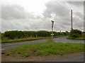
1
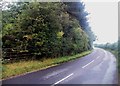
Station Road, Penny Green
Looking towards Whitwell. The rusted gate on the left leads to a large spoil heap, and on the right out of shot is a memorial to a lost life.
Image: © Jonathan Clitheroe
Taken: 2 Aug 2014
0.07 miles
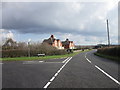
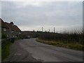
3
Penny Green, Belph
These dwellings are associated with the Welbeck Abbey Estate as evidenced by the faded motifs in the top window arches. There was once a pub here too - the Portland Arms.
Image: © Jonathan Clitheroe
Taken: 2 Aug 2014
0.13 miles
4
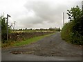
Footpath near Whitwell
From Station Road.
Image: © Steve Fareham
Taken: 5 Aug 2008
0.17 miles
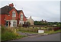
7
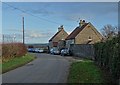
Cottages at Penny Green
The identical dark green doors indicated that these cottages belong to the Welbeck Abbey Estate.
Image: © Neil Theasby
Taken: 30 Nov 2018
0.23 miles