IMAGES TAKEN NEAR TO
Parkway, WORKSOP, S80 4TR
Introduction
This page details the photographs taken nearby to Parkway, S80 4TR by members of the Geograph project.
The Geograph project started in 2005 with the aim of publishing, organising and preserving representative images for every square kilometre of Great Britain, Ireland and the Isle of Man.

There are currently over 7.5m images from over14,400 individuals and you can help contribute to the project by visiting https://www.geograph.org.uk
Image Map
Images are licensed for reuse under creativecommons.org/licenses/by-sa/2.0
Notes
- Clicking on the map will re-center to the selected point.
- The higher the marker number, the further away the image location is from the centre of the postcode.
Image Listing (12 Images Found)
Images are licensed for reuse under creativecommons.org/licenses/by-sa/2.0
Image
Details
Distance
1
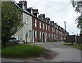
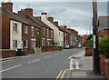
Parkway, Whitwell
A line of terraced houses at the eastern edge of the village.
Image: © Andrew Hill
Taken: 10 May 2011
0.00 miles
2
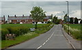
Welcome to Whitwell
Looking along Welbeck Street, the road from Hodthorpe. Whitwell is a large village with a network of approach lanes and streets within the village.
Image: © Andrew Hill
Taken: 10 May 2011
0.05 miles
4
Duke Street, Whitwell
Off Welbeck Street. Leading to Mill Crescent.
Image: © Richard Vince
Taken: 17 Feb 2024
0.11 miles
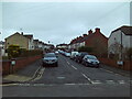
5
Welbeck Street, Whitwell
View from the pavement just about to cross Duke Street.
Image: © Andrew Hill
Taken: 10 May 2011
0.13 miles
6
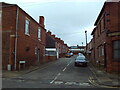
Coronation Street, Whitwell
Off Welbeck Street.
Image: © Richard Vince
Taken: 17 Feb 2024
0.15 miles
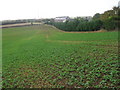
8
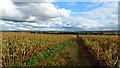
Path running east from Whitwell towards Birks Farm
Image: © Colin Park
Taken: 15 Oct 2020
0.20 miles
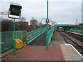
9
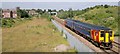
Nottingham-Worksop train approaches Whitwell station
On the Robin Hood Line
Image: © Chris Morgan
Taken: 8 Jul 2013
0.20 miles
10
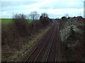
Railway line passing Hodthorpe
Looking towards Shireoaks Junction from the bridge carrying Welbeck Street across the railway on the western edge of Hodthorpe village. Whitwell station is about half a mile behind the photographer.
Image: © Richard Vince
Taken: 17 Feb 2024
0.21 miles