IMAGES TAKEN NEAR TO
Longhurst View, WORKSOP, S80 4QW
Introduction
This page details the photographs taken nearby to Longhurst View, S80 4QW by members of the Geograph project.
The Geograph project started in 2005 with the aim of publishing, organising and preserving representative images for every square kilometre of Great Britain, Ireland and the Isle of Man.

There are currently over 7.5m images from over14,400 individuals and you can help contribute to the project by visiting https://www.geograph.org.uk
Image Map
Images are licensed for reuse under creativecommons.org/licenses/by-sa/2.0
Notes
- Clicking on the map will re-center to the selected point.
- The higher the marker number, the further away the image location is from the centre of the postcode.
Image Listing (21 Images Found)
Images are licensed for reuse under creativecommons.org/licenses/by-sa/2.0
Image
Details
Distance
1
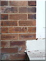
OS benchmark - no 73, Southfield Lane
A cutmark in the brick frontage of a private house on Southfield Lane. Originally levelled at 97.893m, 321'2" above Ordnance Datum Newlyn.
Image: © Richard Law
Taken: 8 Aug 2013
0.04 miles
2
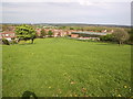
Quarry Field
This field used to be popular with children (myself included) for sledging in the days when winters were winters. The large white building on the horizon of trees (just above the two trees to the left of the field) is the B&Q distribution depot in Worksop circa 8km away, see Image
Image: © Michael Patterson
Taken: 1 May 2005
0.08 miles
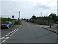
4
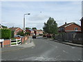
Southfield Lane, Whitwell
Heading south east.
Image: © JThomas
Taken: 28 Aug 2014
0.10 miles
5
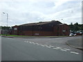
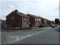
Industrial unit, Whitwell
Off Southfield Lane.
Image: © JThomas
Taken: 28 Aug 2014
0.12 miles
6
Southfield Lane, Whitwell
Heading south east.
Image: © JThomas
Taken: 28 Aug 2014
0.16 miles
7
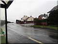
Stormy Day in Whitwell
Decided to ignore the warnings and take a walk during Storm Ciara. Sheltering in the bus shelter
Image: © Stephen Ostler
Taken: 9 Feb 2020
0.16 miles
8
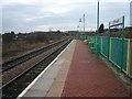
Whitwell Station
One of the stops to Nottingham, on the Robin Hood Line.
Image: © Alan Heardman
Taken: 31 Dec 2007
0.16 miles
9

Whitwell - Station Signal Box
When this photo was taken (September 1983), Whitwell Station (after which the signal box was named) had been demolished and the station buildings moved to the Midland Railway Centre at Butterley. The spoil heap of Whitwell Colliery (closed in June 1986) can be seen behind the signal box. In the early 1980's, the railway line (from Pye Bridge to Worksop) was heavily used by trains transporting coal from the Nottinghamshire and Derbyshire coalfields to the Trent Valley power stations and this photo pictures two coal trains crossing at Whitwell. Although coal traffic has greatly declined, the railway line received a new lease of life in the late 1990's as the "Robin Hood Line". This passenger service connects Nottingham with Worksop via Mansfield and there is now a railway station again at Whitwell.
Image: © Dave Bevis
Taken: 1 Sep 1983
0.20 miles
10
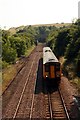
Railway at Whitwell
A Nottingham to Worksop train on the Robin Hood Line is approaching Whitwell station.
Image: © Graham Hogg
Taken: 8 Jul 2013
0.20 miles