IMAGES TAKEN NEAR TO
Skinner Street, WORKSOP, S80 4LE
Introduction
This page details the photographs taken nearby to Skinner Street, S80 4LE by members of the Geograph project.
The Geograph project started in 2005 with the aim of publishing, organising and preserving representative images for every square kilometre of Great Britain, Ireland and the Isle of Man.

There are currently over 7.5m images from over14,400 individuals and you can help contribute to the project by visiting https://www.geograph.org.uk
Image Map
Images are licensed for reuse under creativecommons.org/licenses/by-sa/2.0
Notes
- Clicking on the map will re-center to the selected point.
- The higher the marker number, the further away the image location is from the centre of the postcode.
Image Listing (17 Images Found)
Images are licensed for reuse under creativecommons.org/licenses/by-sa/2.0
Image
Details
Distance
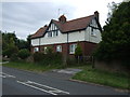
1
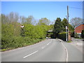
Markland View, Creswell
Close to the north end of the village.
Image: © Richard Vince
Taken: 5 May 2018
0.01 miles
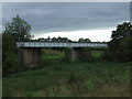
2
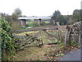
Disused Railway Bridge
This bridge carried a line which linked the now Robin Hood Line at Creswell through Clowne to Seymour Junction near Staveley. For some reason despite the line being closed the tracks were never removed, other than by short sections where they have clearly been stolen for scrap.
Image: © Michael Patterson
Taken: 5 Feb 2006
0.05 miles
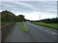
3
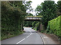
Hazelmere Road, Creswell
Near the northern extremity of the village. The bridge ahead carried the former Midland Railway line from Creswell to Staveley.
Image: © Richard Vince
Taken: 5 May 2018
0.06 miles
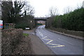
4
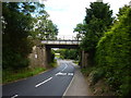
Disused railway bridge over Hazelmere Road
Looking north east.
Image: © JThomas
Taken: 28 Aug 2014
0.08 miles
5
Bridge carrying railway (disused)
The line from Cresswell to Clowne and Chesterfield.
Image: © Peter Barr
Taken: 28 Jul 2012
0.08 miles
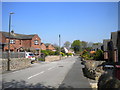
6

Skinner Street, Creswell
Maybe the veteran local MP Dennis Skinner may have something to do with this street name.
I wonder how much longer the telephone box will last, and possibly the post box, too.
Image: © Chris Morgan
Taken: 8 Jul 2013
0.09 miles
8
Disused railway bridge over river
See http://www.geograph.org.uk/photo/1537497 for an alternative view five years earlier.
Image: © JThomas
Taken: 28 Aug 2014
0.10 miles