IMAGES TAKEN NEAR TO
Eyre Street, WORKSOP, S80 4JL
Introduction
This page details the photographs taken nearby to Eyre Street, S80 4JL by members of the Geograph project.
The Geograph project started in 2005 with the aim of publishing, organising and preserving representative images for every square kilometre of Great Britain, Ireland and the Isle of Man.

There are currently over 7.5m images from over14,400 individuals and you can help contribute to the project by visiting https://www.geograph.org.uk
Image Map
Images are licensed for reuse under creativecommons.org/licenses/by-sa/2.0
Notes
- Clicking on the map will re-center to the selected point.
- The higher the marker number, the further away the image location is from the centre of the postcode.
Image Listing (10 Images Found)
Images are licensed for reuse under creativecommons.org/licenses/by-sa/2.0
Image
Details
Distance
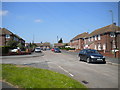
1

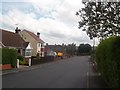
Footpath to Tennyson Road, Creswell
From Eyre Street.
Image: © Richard Vince
Taken: 5 May 2018
0.07 miles
2
Tennyson Road, Creswell
With the end of Shakespeare Avenue on the left.
Image: © Richard Vince
Taken: 5 May 2018
0.08 miles
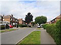
5
A village street in Creswell
Holbeck Street, a residential street off Elmton Road.
Image: © Andrew Hill
Taken: 22 Oct 2011
0.15 miles
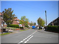
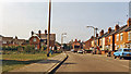
6
Holbeck Street in Creswell
Residential road which joins Elmton Street ahead. There's also a pub - The Black Diamond, which can be seen at the road junction on the left.
Image: © Jonathan Clitheroe
Taken: 2 Aug 2014
0.18 miles
7

Bus stop by the cemetery
Creswell Cemetery on Skinner Street
Image: © Graham Hogg
Taken: 8 Jul 2013
0.19 miles
8
Site of Cresswell & Welbeck station, 1983
View along main street (A616) in Cresswell, where the ex-GC (LD&EC) Langwith Junction (to left) - Beighton Junction (to right) line crossed, until closed completely from 6/1/67, this station having lost its passenger service from 10/9/39, goods from 28/11/49. [Location may be slightly incorrect].
Image: © Ben Brooksbank
Taken: 27 Aug 1983
0.20 miles
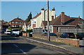
9
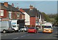
Elmton Road, Creswell
Looking along the street with the mix of residential and small stores and businesses.
Image: © Andrew Hill
Taken: 22 Oct 2011
0.22 miles
10
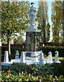
War memorial, Creswell
A significant memorial for this large former mining village.
Image: © Andrew Hill
Taken: 22 Oct 2011
0.25 miles