IMAGES TAKEN NEAR TO
Water Lily Gardens, WORKSOP, S80 4FL
Introduction
This page details the photographs taken nearby to Water Lily Gardens, S80 4FL by members of the Geograph project.
The Geograph project started in 2005 with the aim of publishing, organising and preserving representative images for every square kilometre of Great Britain, Ireland and the Isle of Man.

There are currently over 7.5m images from over14,400 individuals and you can help contribute to the project by visiting https://www.geograph.org.uk
Image Map
Images are licensed for reuse under creativecommons.org/licenses/by-sa/2.0
Notes
- Clicking on the map will re-center to the selected point.
- The higher the marker number, the further away the image location is from the centre of the postcode.
Image Listing (20 Images Found)
Images are licensed for reuse under creativecommons.org/licenses/by-sa/2.0
Image
Details
Distance
1
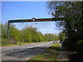
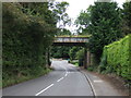
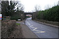
Sheffield Road north of Creswell
Judging by this very substantial warning device, high vehicles striking the low railway bridge on the approach to the village has been a frequent problem. The bridge itself can be seen here: Image
Image: © Richard Vince
Taken: 5 May 2018
0.04 miles
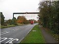
2
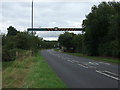
Sheffield Road (A616)
Heading south east. Warning of an upcoming height restriction of a railway bridge.
Image: © JThomas
Taken: 28 Aug 2014
0.04 miles
3
Bridge carrying railway (disused)
The line from Cresswell to Clowne and Chesterfield.
Image: © Peter Barr
Taken: 28 Jul 2012
0.07 miles
4
Disused railway bridge over Hazelmere Road
Looking north east.
Image: © JThomas
Taken: 28 Aug 2014
0.07 miles
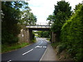
5
Height restriction over A616 on approach to low railway bridge
Image: © Alan Heardman
Taken: 15 Oct 2009
0.07 miles
7
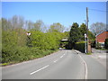
Hazelmere Road, Creswell
Near the northern extremity of the village. The bridge ahead carried the former Midland Railway line from Creswell to Staveley.
Image: © Richard Vince
Taken: 5 May 2018
0.09 miles
8
Disused Railway Bridge
This bridge carried a line which linked the now Robin Hood Line at Creswell through Clowne to Seymour Junction near Staveley. For some reason despite the line being closed the tracks were never removed, other than by short sections where they have clearly been stolen for scrap.
Image: © Michael Patterson
Taken: 5 Feb 2006
0.10 miles
9
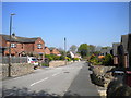
Markland View, Creswell
Close to the north end of the village.
Image: © Richard Vince
Taken: 5 May 2018
0.13 miles