IMAGES TAKEN NEAR TO
Elmton Road, WORKSOP, S80 4DE
Introduction
This page details the photographs taken nearby to Elmton Road, S80 4DE by members of the Geograph project.
The Geograph project started in 2005 with the aim of publishing, organising and preserving representative images for every square kilometre of Great Britain, Ireland and the Isle of Man.

There are currently over 7.5m images from over14,400 individuals and you can help contribute to the project by visiting https://www.geograph.org.uk
Image Map
Images are licensed for reuse under creativecommons.org/licenses/by-sa/2.0
Notes
- Clicking on the map will re-center to the selected point.
- The higher the marker number, the further away the image location is from the centre of the postcode.
Image Listing (48 Images Found)
Images are licensed for reuse under creativecommons.org/licenses/by-sa/2.0
Image
Details
Distance
1
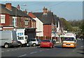
Elmton Road, Creswell
Looking along the street with the mix of residential and small stores and businesses.
Image: © Andrew Hill
Taken: 22 Oct 2011
0.01 miles
2
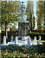
War memorial, Creswell
A significant memorial for this large former mining village.
Image: © Andrew Hill
Taken: 22 Oct 2011
0.04 miles
3
Memorial to the 1950 Creswell Pit Disaster
In the early hours of 26 September 1950, a damaged conveyor belt caught in a machine at the colliery, causing the motor to overheat and catch fire trapping 80 men beyond the flames. They all perished as a result of the fumes and smoke. As word of the disaster spread, Creswell residents rushed to the pithead to offer assistance. One miner, who had broken his back several months before, went down the stricken pit, with a back brace on, to rescue his fellow workers. Serious errors prevented the fire from being extinguished quickly and only 57 bodies were initially recovered and 23 remained underground for the best part of a year. The fire was finally put out after the entire colliery had been sealed to starve it of oxygen, and it did not reopen until Easter 1951, when most of the remaining bodies were recovered. The last three victims were recovered on 11 August 1951, nearly eleven months after the fire.
The enquiry, presided over by the Minister of Fuel and Power Geoffrey Lloyd, described a number of factors involved in the high death rate, including telephones being too far from the face, repair work being done on the "paddy" (the underground train used to convey the men to and from the lift shaft), inadequate air shafts and low water pressure in the fire hoses. (source Wikipedia)
Image: © Colin Park
Taken: 29 Jul 2021
0.05 miles
4
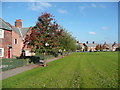
Trees on the edge of the green, Creswell Model Village
The tree in the foreground is a Rowan. These were perhaps replacements for trees planted over a hundred years ago.
Image: © Humphrey Bolton
Taken: 26 Oct 2015
0.07 miles
5
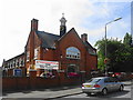
Creswell Social Centre
With the generosity of The Duke of Portland and built by the Bolsover Colliery Company during 1903-04 to provide recreational facilities for the Creswell Company Church Lads Brigade to a design by Percy Houghton in the Arts & Crafts style. Houghton was also responsible for design of the nearby 'Model Village'. During the Great War the Drill Hall was converted into an auxiliary hospital, returning back to the Drill Hall at the end of hostilities and later to a public hall.
Image: © John M
Taken: 7 Aug 2018
0.08 miles
6
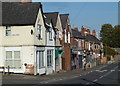
Elmton Road, Creswell
Looking past the end of Ann Street. The former mining village has a number of traditional village shops and businesses.
Image: © Andrew Hill
Taken: 22 Oct 2011
0.08 miles
7
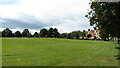
Model Village, Creswell
Creswell Model Village is an arts and crafts style model village. The pit village was built in 1895 by the Bolsover Colliery Company to designs by architect Percy B. Houfton for the workers of Creswell Colliery on land leased from the Welbeck Estate. Influenced by garden village principles, it provided the workers with modern facilities; it had a tramway to deliver coal to the houses. Designed around a large oval village green with an access road through the centre, the houses are of varying styles. The Model as it is known, has been refurbished. (source Wikipedia)
Image: © Colin Park
Taken: 29 Jul 2021
0.08 miles
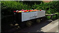
8

Seat on the Green, Creswell 'Model Village'
Image: © Humphrey Bolton
Taken: 26 Oct 2015
0.09 miles
9
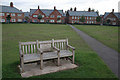
Creswell Model Village, The Green
Built in 1896 to house workers at Creswell Colliery, the village consists of a double ring of houses, separated by a service road, around a large green in the form of an extended octagon. The houses are built in a variety of different designs. After a period of decline from the 1980s, the village has been turned round with the help of an active residents' Association and a large Heritage Lottery Fund award.
The bench in the foreground commemorates the Creswell Colliery Disaster of 1950 and memorialises one of the victims who lived in the Village.
Image: © Alan Murray-Rust
Taken: 30 Sep 2008
0.10 miles
10

Station Hotel and Creswell Junior School
The railway closed in the 1960's. The hotel/pub seems to have closed quite recently.
The railway was recently reopened for passenger traffic between Worksop and Nottingham. The pub looks like it will become flats!
Image: © Chris Morgan
Taken: 8 Jul 2013
0.10 miles