IMAGES TAKEN NEAR TO
Welbeck Street, WORKSOP, S80 4AZ
Introduction
This page details the photographs taken nearby to Welbeck Street, S80 4AZ by members of the Geograph project.
The Geograph project started in 2005 with the aim of publishing, organising and preserving representative images for every square kilometre of Great Britain, Ireland and the Isle of Man.

There are currently over 7.5m images from over14,400 individuals and you can help contribute to the project by visiting https://www.geograph.org.uk
Image Map
Images are licensed for reuse under creativecommons.org/licenses/by-sa/2.0
Notes
- Clicking on the map will re-center to the selected point.
- The higher the marker number, the further away the image location is from the centre of the postcode.
Image Listing (75 Images Found)
Images are licensed for reuse under creativecommons.org/licenses/by-sa/2.0
Image
Details
Distance
1
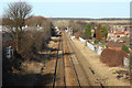
Railway north
View north from the bridge by Crags Business Park
Image: © Richard Croft
Taken: 2 Jan 2012
0.08 miles
2
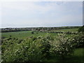
View over Creswell from above Church Hole
Image: © Jonathan Thacker
Taken: 26 May 2018
0.11 miles
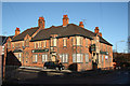
3

Station Hotel and Creswell Junior School
The railway closed in the 1960's. The hotel/pub seems to have closed quite recently.
The railway was recently reopened for passenger traffic between Worksop and Nottingham. The pub looks like it will become flats!
Image: © Chris Morgan
Taken: 8 Jul 2013
0.11 miles
4
Creswell Social Centre
With the generosity of The Duke of Portland and built by the Bolsover Colliery Company during 1903-04 to provide recreational facilities for the Creswell Company Church Lads Brigade to a design by Percy Houghton in the Arts & Crafts style. Houghton was also responsible for design of the nearby 'Model Village'. During the Great War the Drill Hall was converted into an auxiliary hospital, returning back to the Drill Hall at the end of hostilities and later to a public hall.
Image: © John M
Taken: 7 Aug 2018
0.11 miles
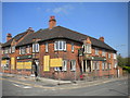
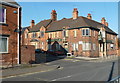
5
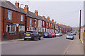
Welbeck Street, Creswell
The line of houses stretches from here into the centre of Creswell village. No doubt at one time many - probably most - of these would have been occupied by miners and their families.
Image: © Stephen McKay
Taken: 18 Apr 2019
0.11 miles
6
The Station Hotel, Creswell
A very substantial (but sadly closed) pub on the corner of Skinner Street (left) and Elmton Road. The railway station, from which it takes its name, is on an embankment behind the pub.
Image: © Richard Vince
Taken: 5 May 2018
0.11 miles
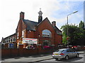
7
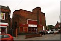
Regors Bingo Hall
Housed in an art deco former cinema. The cinema was also called Regors, after the Rogers family who built it.
Image: © Graham Hogg
Taken: 8 Jul 2013
0.12 miles
8
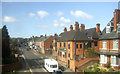
Elmton Road, Creswell
Station Hotel on the right.
Image: © JThomas
Taken: 18 Apr 2014
0.12 miles
9
The Station Hotel
Closed and boarded up Station Hotel at Creswell http://www.geograph.org.uk/photo/1092941
Image: © Richard Croft
Taken: 2 Jan 2012
0.12 miles
10
The Station Hotel, closed, Creswell
It is sad to see a substantial building at the heart of a community boarded up. It is close to the railway line and station, as the name implies.
Image: © Andrew Hill
Taken: 22 Oct 2011
0.12 miles