IMAGES TAKEN NEAR TO
Welbeck Street, WORKSOP, S80 4AN
Introduction
This page details the photographs taken nearby to Welbeck Street, S80 4AN by members of the Geograph project.
The Geograph project started in 2005 with the aim of publishing, organising and preserving representative images for every square kilometre of Great Britain, Ireland and the Isle of Man.

There are currently over 7.5m images from over14,400 individuals and you can help contribute to the project by visiting https://www.geograph.org.uk
Image Map
Images are licensed for reuse under creativecommons.org/licenses/by-sa/2.0
Notes
- Clicking on the map will re-center to the selected point.
- The higher the marker number, the further away the image location is from the centre of the postcode.
Image Listing (49 Images Found)
Images are licensed for reuse under creativecommons.org/licenses/by-sa/2.0
Image
Details
Distance
1
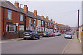
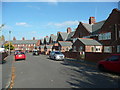
Welbeck Street, Creswell
The line of houses stretches from here into the centre of Creswell village. No doubt at one time many - probably most - of these would have been occupied by miners and their families.
Image: © Stephen McKay
Taken: 18 Apr 2019
0.00 miles
2
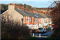
Morven Street
Terraced houses at Creswell
Image: © Richard Croft
Taken: 2 Jan 2012
0.04 miles
3
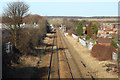
Railway north
View north from the bridge by Crags Business Park
Image: © Richard Croft
Taken: 2 Jan 2012
0.06 miles
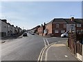
4

Morven Street, Creswell
Traditional terraced housing towards Duchess Street beyond the slight corner to the right.
Image: © Andrew Hill
Taken: 22 Oct 2011
0.08 miles
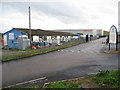
6
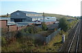
Industrial buildings by the railway at Creswell
Just one line of the railway is in view on the right.
Image: © Andrew Hill
Taken: 22 Oct 2011
0.10 miles
7
The street around Creswell Model Village
As at new Bolsover, the houses were built with their backs to the street. There was a tramway that delivered coal to the houses and took away 'night soil' from the ash privies.
Image: © Humphrey Bolton
Taken: 26 Oct 2015
0.14 miles
8
Morven Street, Creswell
From the junction with Duchess Street and Duke Street
Image: © Andrew Abbott
Taken: 30 Mar 2019
0.15 miles
9
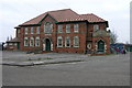
Miners Welfare
Perhaps one of the better examples of a former Miners Welfare building. The stone plaque above the door on the right acclaims "Publ(i)c Hal(l) Entranc(e)" The final 'l' in Hall and the final 'e' in Entrance are both smaller letters inside the previous letter. The 'i' in Public is also shortened to reduce the spacing. Difficult to tell if this was planned or an oversight when marking out for carving.
Image: © Michael Patterson
Taken: 5 Feb 2006
0.18 miles
10
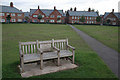
Creswell Model Village, The Green
Built in 1896 to house workers at Creswell Colliery, the village consists of a double ring of houses, separated by a service road, around a large green in the form of an extended octagon. The houses are built in a variety of different designs. After a period of decline from the 1980s, the village has been turned round with the help of an active residents' Association and a large Heritage Lottery Fund award.
The bench in the foreground commemorates the Creswell Colliery Disaster of 1950 and memorialises one of the victims who lived in the Village.
Image: © Alan Murray-Rust
Taken: 30 Sep 2008
0.18 miles