IMAGES TAKEN NEAR TO
Mansfield Road, WORKSOP, S80 4AF
Introduction
This page details the photographs taken nearby to Mansfield Road, S80 4AF by members of the Geograph project.
The Geograph project started in 2005 with the aim of publishing, organising and preserving representative images for every square kilometre of Great Britain, Ireland and the Isle of Man.

There are currently over 7.5m images from over14,400 individuals and you can help contribute to the project by visiting https://www.geograph.org.uk
Image Map
Images are licensed for reuse under creativecommons.org/licenses/by-sa/2.0
Notes
- Clicking on the map will re-center to the selected point.
- The higher the marker number, the further away the image location is from the centre of the postcode.
Image Listing (57 Images Found)
Images are licensed for reuse under creativecommons.org/licenses/by-sa/2.0
Image
Details
Distance
1

Terraced houses, Mansfield Road, Creswell
Image: © Jonathan Thacker
Taken: 26 May 2018
0.01 miles


5
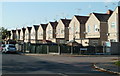
Duchess Street, Creswell
A row of houses line one side of the street with a designated green on the other.
Image: © Andrew Hill
Taken: 22 Oct 2011
0.07 miles

9
A616 towards new Ollerton
Heading south east.
Image: © JThomas
Taken: 28 Aug 2014
0.12 miles