IMAGES TAKEN NEAR TO
Mansfield Road, WORKSOP, S80 4AB
Introduction
This page details the photographs taken nearby to Mansfield Road, S80 4AB by members of the Geograph project.
The Geograph project started in 2005 with the aim of publishing, organising and preserving representative images for every square kilometre of Great Britain, Ireland and the Isle of Man.

There are currently over 7.5m images from over14,400 individuals and you can help contribute to the project by visiting https://www.geograph.org.uk
Image Map
Images are licensed for reuse under creativecommons.org/licenses/by-sa/2.0
Notes
- Clicking on the map will re-center to the selected point.
- The higher the marker number, the further away the image location is from the centre of the postcode.
Image Listing (57 Images Found)
Images are licensed for reuse under creativecommons.org/licenses/by-sa/2.0
Image
Details
Distance
1
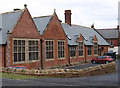
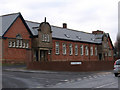
Creswell - former infants school
This former infants school, built 1874, lay derelict for 20 years but has recently been converted into apartments.
Image: © Dave Bevis
Taken: 22 Jan 2011
0.06 miles
2
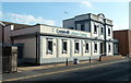
Creswell Baths
Built by the Miners’ Welfare Fund in 1924 on a site donated by the Duke of Portland.
Image: © Andrew Abbott
Taken: 30 Mar 2019
0.07 miles
3
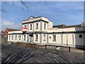
Creswell Leisure Centre
A distinctive swimming bath and leisure centre building on Duke Street.
Image: © Andrew Hill
Taken: 22 Oct 2011
0.07 miles
4
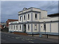
Creswell - Leisure Centre
The only public swimming baths within the Bolsover District Council area.
Image: © Dave Bevis
Taken: 25 Feb 2007
0.07 miles
5
Creswell - former secondary school
This former secondary school, built 1901, lay derelict for 20 years but has recently been converted into apartments.
Image: © Dave Bevis
Taken: 22 Jan 2011
0.07 miles
6
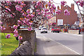
Elmton Road, Creswell
Creswell's principal street seen from close to the junction with Mansfield Road.
Image: © Stephen McKay
Taken: 18 Apr 2019
0.08 miles
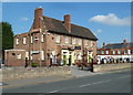
7
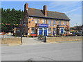
Ours Bar and Lounge
This troubled pub re-opened as a 'community' local last December. Since closure of the colliery in 1991 the pub has had a number of names and owners and problems with clientele. Maybe this is a final opportunity to re-invent itself.
Creswell is an archetypal pit village surrounded by countryside with a population of 5000. Before the pit closed the population reached 6500 shrinking to 4800 but now recovering. It still retains a Bingo Hall.
In the shop I looked into you could only buy a cheap sliced white loaf.
Image: © John M
Taken: 7 Aug 2018
0.09 miles
8
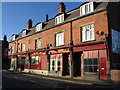
Creswell - Portland Buildings on Elmton Road
Image: © Dave Bevis
Taken: 26 Dec 2008
0.09 miles
9
Restaurant in Creswell
Viva la Mamma is at the main junction in the village between the A616 and Elmton Road.
Image: © Andrew Hill
Taken: 22 Oct 2011
0.09 miles
10
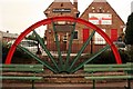
Colliery winding wheel
Presumably from the local colliery which closed in 1992. The pub/restaurant behind is displaying a poster from the football World Cup that is now 3 years out of date.
Image: © Graham Hogg
Taken: 8 Jul 2013
0.10 miles