IMAGES TAKEN NEAR TO
Briar Lea, WORKSOP, S80 3QL
Introduction
This page details the photographs taken nearby to Briar Lea, S80 3QL by members of the Geograph project.
The Geograph project started in 2005 with the aim of publishing, organising and preserving representative images for every square kilometre of Great Britain, Ireland and the Isle of Man.

There are currently over 7.5m images from over14,400 individuals and you can help contribute to the project by visiting https://www.geograph.org.uk
Image Map
Images are licensed for reuse under creativecommons.org/licenses/by-sa/2.0
Notes
- Clicking on the map will re-center to the selected point.
- The higher the marker number, the further away the image location is from the centre of the postcode.
Image Listing (15 Images Found)
Images are licensed for reuse under creativecommons.org/licenses/by-sa/2.0
Image
Details
Distance
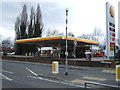
1
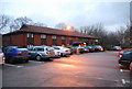
Travelodge, Worksop
A place to rest your head for the night, just off the Worksop bypass.
Image: © N Chadwick
Taken: 20 Dec 2008
0.14 miles
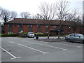
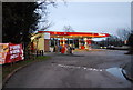
3
The Little Chef, Worksop
Just off the Worksop bypass.
Image: © N Chadwick
Taken: 20 Dec 2008
0.16 miles
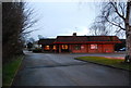
6
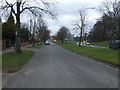
Old Mansfield Road, Worksop
The newer road runs beside it.
Image: © JThomas
Taken: 17 Mar 2014
0.17 miles
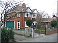
9
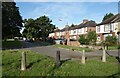
Houses on Mansfield Road
A residential service road which I would guess was the original main road at one time.
Image: © Des Blenkinsopp
Taken: 26 Aug 2023
0.19 miles
10
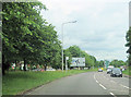
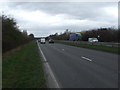
A60 east approaching A57 roundabout
West of Worksop town centre
Image: © John Firth
Taken: 12 Jun 2012
0.19 miles