IMAGES TAKEN NEAR TO
Broad Lane, WORKSOP, S80 3NL
Introduction
This page details the photographs taken nearby to Broad Lane, S80 3NL by members of the Geograph project.
The Geograph project started in 2005 with the aim of publishing, organising and preserving representative images for every square kilometre of Great Britain, Ireland and the Isle of Man.

There are currently over 7.5m images from over14,400 individuals and you can help contribute to the project by visiting https://www.geograph.org.uk
Image Map
Images are licensed for reuse under creativecommons.org/licenses/by-sa/2.0
Notes
- Clicking on the map will re-center to the selected point.
- The higher the marker number, the further away the image location is from the centre of the postcode.
Image Listing (18 Images Found)
Images are licensed for reuse under creativecommons.org/licenses/by-sa/2.0
Image
Details
Distance
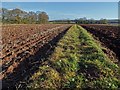
2
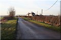
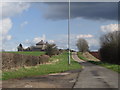
Broad Lane
Broad Lane starts off Broad on thois side of the A60 but soon narrows to a potholed lane.
Image: © Jonathan Thacker
Taken: 18 Jan 2023
0.02 miles
3
Two pairs of semis on Broad Lane
In arable farm land, near Welbeck.
Image: © Peter Barr
Taken: 18 Jan 2014
0.02 miles
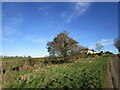
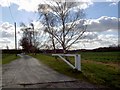
4
Broad Lane
Broad Lane (I know it isn't!) leads past the farm workers houses and on to the tunnel end at South Lodge. See Image
Image: © Michael Patterson
Taken: 21 Feb 2006
0.06 miles
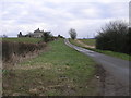
7
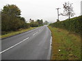
Broad Lane - Approaching Junction with A60 (Mansfield Road)
Image: © Alan Heardman
Taken: 15 Oct 2009
0.12 miles
8
Welcome to Nottinghamshire - Robin Hood Country
Bassetlaw District.
Image: © JThomas
Taken: 17 Mar 2014
0.13 miles
9
Path across farmland north of New Farm
Image: © Neil Theasby
Taken: 30 Nov 2018
0.14 miles
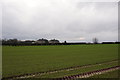
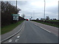
10
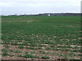
Crop field east of the A60
Towards Ox Pasture Farm.
Image: © JThomas
Taken: 17 Mar 2014
0.14 miles