IMAGES TAKEN NEAR TO
Tranker Lane, WORKSOP, S80 3LG
Introduction
This page details the photographs taken nearby to Tranker Lane, S80 3LG by members of the Geograph project.
The Geograph project started in 2005 with the aim of publishing, organising and preserving representative images for every square kilometre of Great Britain, Ireland and the Isle of Man.

There are currently over 7.5m images from over14,400 individuals and you can help contribute to the project by visiting https://www.geograph.org.uk
Image Map
Images are licensed for reuse under creativecommons.org/licenses/by-sa/2.0
Notes
- Clicking on the map will re-center to the selected point.
- The higher the marker number, the further away the image location is from the centre of the postcode.
Image Listing (78 Images Found)
Images are licensed for reuse under creativecommons.org/licenses/by-sa/2.0
Image
Details
Distance
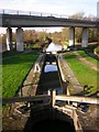
1
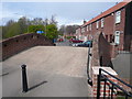
Chesterfield Canal Bridge - View of Tranker Lane
Image: © Alan Heardman
Taken: 15 Apr 2008
0.05 miles
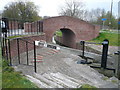
5
Haggonfields Lock
Lock number 46 on the Chesterfield Canal at Rhodesia, with the A57 bridge overhead
Image: © Richard Croft
Taken: 27 Nov 2009
0.07 miles
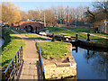
6
Chesterfield Canal - Haggonfields Lock No 46
Image: © Alan Heardman
Taken: 15 Apr 2008
0.07 miles
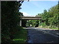
7
Chesterfield Canal
Near the A57 viaduct.
http://www.chesterfield-canal-trust.org.uk/index.shtml
Image: © Steve Fareham
Taken: 17 Feb 2008
0.08 miles
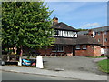
8

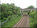
Railway and Tranker Wood from Tranker Lane
Image: © Tim Glover
Taken: 1 Jun 2012
0.08 miles
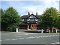
9
A57 bridge over Shireoaks Road
Heading west.
Image: © JThomas
Taken: 28 Aug 2014
0.09 miles
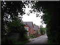
10
Bridge 79A carries the A57 over the railway connecting Shireoaks East Junction and Woodend Junction
Image: © Tim Glover
Taken: 1 Jun 2012
0.09 miles