IMAGES TAKEN NEAR TO
Ladyfield Road, WORKSOP, S80 3JS
Introduction
This page details the photographs taken nearby to Ladyfield Road, S80 3JS by members of the Geograph project.
The Geograph project started in 2005 with the aim of publishing, organising and preserving representative images for every square kilometre of Great Britain, Ireland and the Isle of Man.

There are currently over 7.5m images from over14,400 individuals and you can help contribute to the project by visiting https://www.geograph.org.uk
Image Map
Images are licensed for reuse under creativecommons.org/licenses/by-sa/2.0
Notes
- Clicking on the map will re-center to the selected point.
- The higher the marker number, the further away the image location is from the centre of the postcode.
Image Listing (48 Images Found)
Images are licensed for reuse under creativecommons.org/licenses/by-sa/2.0
Image
Details
Distance
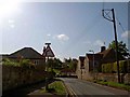
1
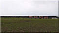
Houses beyond Lady Field
Semi-detached houses and a bungalow seen in dull lighting from Harthill Lane, west of the village of Thorpe Salvin.
Image: © Trevor Littlewood
Taken: 10 Mar 2013
0.05 miles
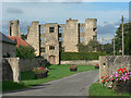
2
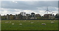
Thorpe Salvin from the north
.
Thorpe Salvin from the north, showing the ruined Elizabethan mansion of Thorpe Hall to the left; St. Peter’s Church, centre, and two of the three wind turbines on Loscar Common looming over the village.
Image: © Mike Nield
Taken: 25 Oct 2017
0.10 miles
3
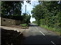
Harthill Road, Thorpe Salvin
Heading west out of the village.
Image: © JThomas
Taken: 28 Aug 2014
0.11 miles
5
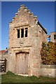
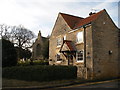
Old Hall Gatehouse
Only the gatehouse and south front remain of Henry Sandford's manor house of c1575
Image: © Richard Croft
Taken: 9 Nov 2007
0.13 miles
7
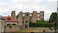
Old Hall and Gatehouse Remains
The old hall is essentially just the south wall but to full height
Image: © Kevin Waterhouse
Taken: 23 Jul 2018
0.13 miles
8
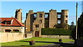
The Old Hall at Thorpe Salvin
The Old Hall was designed and built by Robert Smythson in 1570. It was built on the site of the previous manor house which was the residence of an earlier lord of the manor, Sir Bryan Sandford, Knight, who fought for Henry Tudor at the Battle of Bosworth Field. In 1636, the hall was bought by Edward Osborne. When his descendant Thomas Osborne became Duke of Leeds, he moved out to a grander property in Kiveton Park, and the hall fell into disuse. It was partially demolished in the 1820s, with only the south front now remaining. It is Grade II listed.
Image: © Colin Park
Taken: 15 Oct 2020
0.13 miles
10
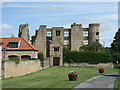
Thorpe Hall, Thorpe Salvin
Remains of a manor house designed and built by Robert Smythson in 1570.
Image: © JThomas
Taken: 28 Aug 2014
0.13 miles