IMAGES TAKEN NEAR TO
Common Road, WORKSOP, S80 3JJ
Introduction
This page details the photographs taken nearby to Common Road, S80 3JJ by members of the Geograph project.
The Geograph project started in 2005 with the aim of publishing, organising and preserving representative images for every square kilometre of Great Britain, Ireland and the Isle of Man.

There are currently over 7.5m images from over14,400 individuals and you can help contribute to the project by visiting https://www.geograph.org.uk
Image Map
Images are licensed for reuse under creativecommons.org/licenses/by-sa/2.0
Notes
- Clicking on the map will re-center to the selected point.
- The higher the marker number, the further away the image location is from the centre of the postcode.
Image Listing (20 Images Found)
Images are licensed for reuse under creativecommons.org/licenses/by-sa/2.0
Image
Details
Distance
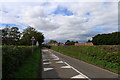
1
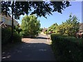
Common Road in Thorpe Salvin
Looking towards the main street on a warm Monday in mid July.
Image: © Jonathan Clitheroe
Taken: 17 Jul 2017
0.10 miles
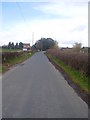
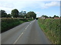
4
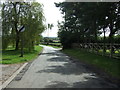
Common Road
Heading south east out of Thorpe Salvin.
Image: © JThomas
Taken: 28 Aug 2014
0.15 miles
5
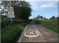
Entering Thorpe Salvin
Heading west on National Cycle Route 6 (Worksop Road).
Image: © JThomas
Taken: 28 Aug 2014
0.15 miles
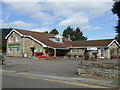
6
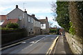
Village street, Thorpe Salvin
Worksop Road, looking west. This is the main village street.
Image: © Andrew Hill
Taken: 26 Feb 2011
0.16 miles
7
National Cycle Route 6
Worksop Road heading west.
Image: © JThomas
Taken: 28 Aug 2014
0.17 miles
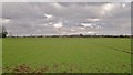
8
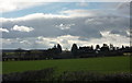
View from Back Lane
Looking across fields to the southern end of the village of Thorpe Salvin.
Image: © Andrew Hill
Taken: 26 Feb 2011
0.18 miles