IMAGES TAKEN NEAR TO
Water Dene, S80 3GL
Introduction
This page details the photographs taken nearby to Water Dene, S80 3GL by members of the Geograph project.
The Geograph project started in 2005 with the aim of publishing, organising and preserving representative images for every square kilometre of Great Britain, Ireland and the Isle of Man.

There are currently over 7.5m images from over14,400 individuals and you can help contribute to the project by visiting https://www.geograph.org.uk
Image Map
Images are licensed for reuse under creativecommons.org/licenses/by-sa/2.0
Notes
- Clicking on the map will re-center to the selected point.
- The higher the marker number, the further away the image location is from the centre of the postcode.
Image Listing (73 Images Found)
Images are licensed for reuse under creativecommons.org/licenses/by-sa/2.0
Image
Details
Distance
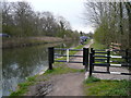
1
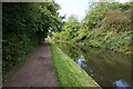
Route 6
NCN route 6 on a recently surfaced stretch of the Chesterfield Canal towpath
Image: © Richard Croft
Taken: 5 Jun 2010
0.10 miles


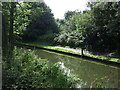
4
The Chesterfield Canal east of Rhodesia
Image: © Neil Theasby
Taken: 27 May 2022
0.11 miles
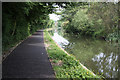
5
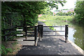
Stile on route 6
Anti-motorbike measures on NCN route 6 along the Chesterfield Canal towpath
Image: © Richard Croft
Taken: 5 Jun 2010
0.12 miles
6
Chesterfield Canal - Fishing in the Rain
Image: © Alan Heardman
Taken: 15 Apr 2008
0.13 miles
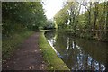
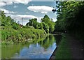
8

Chesterfield Canal in Rhodesia
That's Rhodesia in Nottinghamshire.The lock in the distance is Deep Lock,no.47.
Image: © Graham Hogg
Taken: 30 Apr 2012
0.13 miles