IMAGES TAKEN NEAR TO
Sandy Lane, WORKSOP, S80 3FH
Introduction
This page details the photographs taken nearby to Sandy Lane, S80 3FH by members of the Geograph project.
The Geograph project started in 2005 with the aim of publishing, organising and preserving representative images for every square kilometre of Great Britain, Ireland and the Isle of Man.

There are currently over 7.5m images from over14,400 individuals and you can help contribute to the project by visiting https://www.geograph.org.uk
Image Map
Images are licensed for reuse under creativecommons.org/licenses/by-sa/2.0
Notes
- Clicking on the map will re-center to the selected point.
- The higher the marker number, the further away the image location is from the centre of the postcode.
Image Listing (89 Images Found)
Images are licensed for reuse under creativecommons.org/licenses/by-sa/2.0
Image
Details
Distance
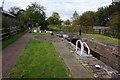
1
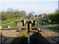
Deep Lock
Deep Lock is number 47 on the Chesterfield Canal
Image: © Stephen Dawson
Taken: 17 Apr 2005
0.00 miles
2
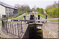
Deep Lock
Deep Lock, in the outskirts of Worksop, is no 47 on the Chesterfield Canal.
Image: © Stephen McKay
Taken: 18 Apr 2019
0.01 miles
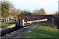
3
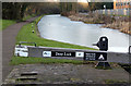
Frozen pound above Deep Lock
Chesterfield Canal on the outskirts of Worksop.
Image: © Alan Murray-Rust
Taken: 20 Jan 2015
0.01 miles
4
Chesterfield Canal - Approaching Deep Lock No 47
Image: © Alan Heardman
Taken: 15 Apr 2008
0.01 miles
6
Deep Lock No 47 on the Chesterfield Canal
Image: © Mat Fascione
Taken: 22 May 2016
0.02 miles
7
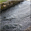
Water texture
Spillway at Deep Lock, Worksop.
Image: © Alan Murray-Rust
Taken: 20 Jan 2015
0.02 miles

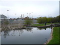
9

The Chesterfield Canal south of Shireoaks Road
Image: © Neil Theasby
Taken: 27 May 2022
0.02 miles
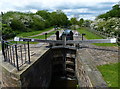
10
Deep Lock, Worksop
The lower gates with Highground Bridge (41) beyond.
Image: © Alan Murray-Rust
Taken: 20 Jan 2015
0.02 miles