IMAGES TAKEN NEAR TO
Nursery Gardens, WORKSOP, S80 3EL
Introduction
This page details the photographs taken nearby to Nursery Gardens, S80 3EL by members of the Geograph project.
The Geograph project started in 2005 with the aim of publishing, organising and preserving representative images for every square kilometre of Great Britain, Ireland and the Isle of Man.

There are currently over 7.5m images from over14,400 individuals and you can help contribute to the project by visiting https://www.geograph.org.uk
Image Map
Images are licensed for reuse under creativecommons.org/licenses/by-sa/2.0
Notes
- Clicking on the map will re-center to the selected point.
- The higher the marker number, the further away the image location is from the centre of the postcode.
Image Listing (7 Images Found)
Images are licensed for reuse under creativecommons.org/licenses/by-sa/2.0
Image
Details
Distance
1

Worksop Manor, kitchen garden, Menagerie Wood and a housing estate: aerial 2017
Image: © Chris
Taken: 19 Sep 2017
0.10 miles
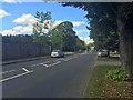
3
A 60 entering Worksop near Worksop Manor
Image: © John Firth
Taken: 24 Jan 2015
0.19 miles
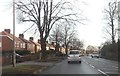
4
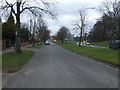
A60 Mansfield Road
West Wood on the left.
Image: © Julian P Guffogg
Taken: 5 May 2013
0.20 miles
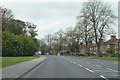
6
Old Mansfield Road, Worksop
The newer road runs beside it.
Image: © JThomas
Taken: 17 Mar 2014
0.22 miles
