IMAGES TAKEN NEAR TO
Rhodesia, WORKSOP, S80 3DN
Introduction
This page details the photographs taken nearby to S80 3DN by members of the Geograph project.
The Geograph project started in 2005 with the aim of publishing, organising and preserving representative images for every square kilometre of Great Britain, Ireland and the Isle of Man.

There are currently over 7.5m images from over14,400 individuals and you can help contribute to the project by visiting https://www.geograph.org.uk
Image Map
Images are licensed for reuse under creativecommons.org/licenses/by-sa/2.0
Notes
- Clicking on the map will re-center to the selected point.
- The higher the marker number, the further away the image location is from the centre of the postcode.
Image Listing (5 Images Found)
Images are licensed for reuse under creativecommons.org/licenses/by-sa/2.0
Image
Details
Distance
2
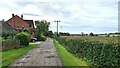
Lady Lea Farm
Or should that be Lady Lee Farm? - the spelling seems to be quite fluid.
Image: © Jonathan Thacker
Taken: 22 Aug 2015
0.01 miles
4
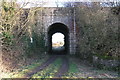
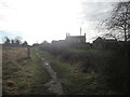
Robin Hood Line Access Bridge
This is Bridge PSE 76 as the Rail Authority tell us should we witness anything striking the bridge. The bridge provides farm access to fields either side of the line.
Image: © Michael Patterson
Taken: 21 Jan 2006
0.22 miles