IMAGES TAKEN NEAR TO
Water Meadows, WORKSOP, S80 3DF
Introduction
This page details the photographs taken nearby to Water Meadows, S80 3DF by members of the Geograph project.
The Geograph project started in 2005 with the aim of publishing, organising and preserving representative images for every square kilometre of Great Britain, Ireland and the Isle of Man.

There are currently over 7.5m images from over14,400 individuals and you can help contribute to the project by visiting https://www.geograph.org.uk
Image Map
Images are licensed for reuse under creativecommons.org/licenses/by-sa/2.0
Notes
- Clicking on the map will re-center to the selected point.
- The higher the marker number, the further away the image location is from the centre of the postcode.
Image Listing (7 Images Found)
Images are licensed for reuse under creativecommons.org/licenses/by-sa/2.0
Image
Details
Distance
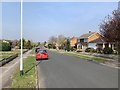
2
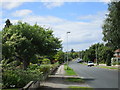
Water Meadows
It's the name of the street and not a description of what is there! Suburban Worksop.
Image: © Jonathan Thacker
Taken: 8 Jul 2016
0.19 miles
3
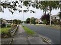
Water Meadows, Worksop
Quiet street in South West of Worksop
Image: © Stephen Ostler
Taken: 16 Oct 2021
0.19 miles
4
Water Meadows, Worksop
A quiet street in the suburbs of Worksop.
Image: © Andrew Abbott
Taken: 30 Mar 2019
0.22 miles
5
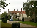
Park Cottage, Water Meadows
The size of the house belies its 'Cottage' name; it was originally part of the Worksop Manor Estate. Its earliest parts date back to around 1700, with expansion through the 18th and 19th centuries. Listed Grade II.
Image: © Alan Murray-Rust
Taken: 4 Oct 2015
0.23 miles
6
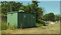
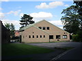
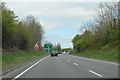
Gas governor, Worksop
By the A57 at the Millhouse roundabout.
Image: © Derek Harper
Taken: 25 Jun 2018
0.24 miles