IMAGES TAKEN NEAR TO
Carburton, WORKSOP, S80 3BU
Introduction
This page details the photographs taken nearby to S80 3BU by members of the Geograph project.
The Geograph project started in 2005 with the aim of publishing, organising and preserving representative images for every square kilometre of Great Britain, Ireland and the Isle of Man.

There are currently over 7.5m images from over14,400 individuals and you can help contribute to the project by visiting https://www.geograph.org.uk
Image Map
Images are licensed for reuse under creativecommons.org/licenses/by-sa/2.0
Notes
- Clicking on the map will re-center to the selected point.
- The higher the marker number, the further away the image location is from the centre of the postcode.
Image Listing (40 Images Found)
Images are licensed for reuse under creativecommons.org/licenses/by-sa/2.0
Image
Details
Distance
1
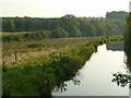
Carburton Water Meadows
The upper supply leat at Pipers Lane, looking across Middle Meadow.
Image: © Alan Murray-Rust
Taken: 4 Oct 2015
0.01 miles
2
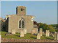
Church of St Giles, Carburton
View from the west.
Image: © Alan Murray-Rust
Taken: 4 Oct 2015
0.03 miles
3
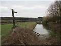
Flood Dyke and footpath at Carburton
The Flood Dyke is a parallel channel of the River Poulter and was designed as an irrigation channel to provide rich meadowland.
Image: © Jonathan Thacker
Taken: 23 Feb 2018
0.03 miles
4
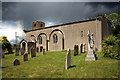
St.Giles' church
St.Giles' church has a blocked 12th century south arcade with 13th century windows re-set in the wall and some small Norman windows in the chancel. A welcome shelter for a cyclist avoiding the approaching downpour
Image: © Richard Croft
Taken: 11 Jun 2011
0.03 miles
5
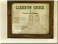
Church of St Giles, Carburton
Tables of Fees. An interesting insight into church arrangements.
Image: © Alan Murray-Rust
Taken: 4 Oct 2015
0.03 miles
6
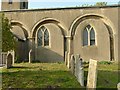
Church of St Giles, Carburton
The 12th century arcading of the south wall. The half arch to the left suggests that the church may have been longer at one stage.
Image: © Alan Murray-Rust
Taken: 4 Oct 2015
0.03 miles
7
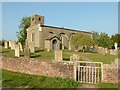
Church of St Giles, Carburton
View from the south west with the gateway into the churchyard.
Image: © Alan Murray-Rust
Taken: 4 Oct 2015
0.03 miles
8
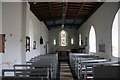
St.Giles' church interior
Simple interior to the ancient church of St.Giles at Carburton http://www.geograph.org.uk/photo/2466709
Image: © Richard Croft
Taken: 11 Jun 2011
0.03 miles
9
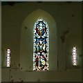
Church of St Giles, Carburton
The east windows, with what appears to be medieval glass in the main light.
Image: © Alan Murray-Rust
Taken: 4 Oct 2015
0.03 miles
10
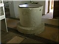
Church of St Giles, Carburton
The Norman font.
Image: © Alan Murray-Rust
Taken: 4 Oct 2015
0.03 miles