IMAGES TAKEN NEAR TO
Clumber Park, WORKSOP, S80 3AU
Introduction
This page details the photographs taken nearby to S80 3AU by members of the Geograph project.
The Geograph project started in 2005 with the aim of publishing, organising and preserving representative images for every square kilometre of Great Britain, Ireland and the Isle of Man.

There are currently over 7.5m images from over14,400 individuals and you can help contribute to the project by visiting https://www.geograph.org.uk
Image Map
Images are licensed for reuse under creativecommons.org/licenses/by-sa/2.0
Notes
- Clicking on the map will re-center to the selected point.
- The higher the marker number, the further away the image location is from the centre of the postcode.
Image Listing (6 Images Found)
Images are licensed for reuse under creativecommons.org/licenses/by-sa/2.0
Image
Details
Distance
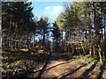
3
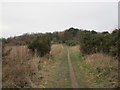
Route 6
NCN Route 6 in Forest Cottages Plantation in Manton Forest
Image: © Richard Croft
Taken: 5 Jun 2010
0.10 miles
4
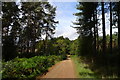
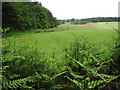
Cycle Route 6 through Forest Cottages Plantation
Forestry Commission land on the north side of Clumber Park
Image: © Tim Heaton
Taken: 5 Oct 2013
0.15 miles
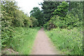
6
Bridleway to Windmill Lane
Crosses College Pines Golf Course.
Image: © Jonathan Thacker
Taken: 18 Jan 2019
0.24 miles