IMAGES TAKEN NEAR TO
Martlet Way, WORKSOP, S80 2SJ
Introduction
This page details the photographs taken nearby to Martlet Way, S80 2SJ by members of the Geograph project.
The Geograph project started in 2005 with the aim of publishing, organising and preserving representative images for every square kilometre of Great Britain, Ireland and the Isle of Man.

There are currently over 7.5m images from over14,400 individuals and you can help contribute to the project by visiting https://www.geograph.org.uk
Image Map
Images are licensed for reuse under creativecommons.org/licenses/by-sa/2.0
Notes
- Clicking on the map will re-center to the selected point.
- The higher the marker number, the further away the image location is from the centre of the postcode.
Image Listing (14 Images Found)
Images are licensed for reuse under creativecommons.org/licenses/by-sa/2.0
Image
Details
Distance
1
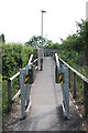
Squeeze stile
One of numerous anti-motorbike measures along NCN route 6 around Worksop, this one guards the approach to the footbridge over the A57
Image: © Richard Croft
Taken: 5 Jun 2010
0.06 miles
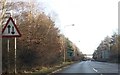
3
Approaching a footbridge over the A57
Cycle Route 6 about to enter Worksop
Image: © Tim Heaton
Taken: 5 Oct 2013
0.10 miles
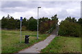
4
A57 west
View west from the footbridge
Image: © Richard Croft
Taken: 5 Jun 2010
0.12 miles
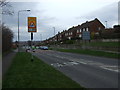
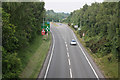
6
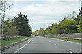
A57 near Worksop
A footbridge crosses ahead.
Image: © Julian P Guffogg
Taken: 5 May 2013
0.14 miles