IMAGES TAKEN NEAR TO
Dukeries Crescent, WORKSOP, S80 2QP
Introduction
This page details the photographs taken nearby to Dukeries Crescent, S80 2QP by members of the Geograph project.
The Geograph project started in 2005 with the aim of publishing, organising and preserving representative images for every square kilometre of Great Britain, Ireland and the Isle of Man.

There are currently over 7.5m images from over14,400 individuals and you can help contribute to the project by visiting https://www.geograph.org.uk
Image Map
Images are licensed for reuse under creativecommons.org/licenses/by-sa/2.0
Notes
- Clicking on the map will re-center to the selected point.
- The higher the marker number, the further away the image location is from the centre of the postcode.
Image Listing (5 Images Found)
Images are licensed for reuse under creativecommons.org/licenses/by-sa/2.0
Image
Details
Distance
3
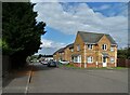
Forest Rise, Manton
A small housing development on the southern fringe of Worksop
Image: © Neil Theasby
Taken: 16 Sep 2021
0.22 miles
4
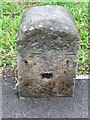
Old Milestone
Old Milestone on the B6040 at Worksop, Nottinghamshire. For overall view see http://www.geograph.org.uk/photo/4595210
Image: © Keith Evans
Taken: 20 Jun 2015
0.24 miles
5
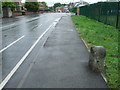
Milestone
Old Milestone on the B6040 at Worksop, Nottinghamshire. For close up view see http://www.geograph.org.uk/photo/4595207
Image: © Keith Evans
Taken: 20 Jun 2015
0.25 miles